The Black Mountain

  • The awesome MakerMoot is coming up (13-15th Nov 2026), Visit the TORM & ARM markets,and have space back at camp to work on projects and enjoy great company. PLEASE CLICK HERE for more information.

Dan00001

Settler
Nov 13, 2023
898
964
37
Wales
Haven't been posting much recently, I've just been so busy. Anyway, last week I walked 25km~ across The Black Mountain with an overnight stop near Garreg Las. This was my first time properly walking in this area and wow it's absolutely stunning. After leaving the main paths around Llyn y Fan Fach at around 5pm Wednesday evening, I didn't see a single person until I got back to Glyntawe at lunch time the following day. Took a detour to visit the Wellington bomber on my way back and got a load of nav practice in, I have assessments with MR in a couple months so need to get lots of nave practice in!. Ate my body weight in wild blueberries and blackberries.

Being an area of limestone the landscape is riddled with sink holes, some the size of houses, and ancient river beds (see photos). Looking up the Fan Hir escarpment, you get a great view of the different layers of sandstone and the lateral moraine formed during the glacial period. on Top of Garreg Las there are two pretty large ancient burial chambers. A very interesting area of the Brecon Beacons to walk in!


I take my hat off to the teams who do MR there; that's hard land, and harder yet it Winter.
Beautiful though, and so rich in heritage.
This is Western Beacons MRT area. They have a massive area to cover ranging from Barry in South Wales all the way up to past Aberaeron. I don't think they get many call-outs in this area simply because it doesn't see a large amount of footfall.
 
  • Like
Reactions: Toddy
In winter if there's snow on the ground this will be very difficult terrain, much of the paths are not that well troden and you have to be very careful of sink holes. I still want to try walking here in winter though!
 
  • Like
Reactions: Toddy
:aargh::approve::sick: Sick with envy, been years since I've been there (since Chernobyl in fact). Great trip and pics.

It'll be at least October before I'll be fit enough again and able to do a trip, and it'll have to be a shorter distance than that.
 
  • Like
Reactions: Dan00001
:aargh::approve::sick: Sick with envy, been years since I've been there (since Chernobyl in fact). Great trip and pics.

It'll be at least October before I'll be fit enough again and able to do a trip, and it'll have to be a shorter distance than that.
Thank you. I'm already desperate to get back out again. This walk was Nuttall 13.6 with the Wellington Bomber site at Carreg Goch added on. I'd like to explore the vast area to the west of Carreg Goch up to Garreg Las so will be planning my own route around that area.

 
Something new for me there, Nuttalls & Hewitts eh? I've heard of the Munroes etc but peak bagging has never interested me. Ready-made but not touristy walking routes for unknown areas saves me loads of stress.
Haven't able to make sense of their website yet or how to come up with the proposed route.
 
  • Like
Reactions: Dan00001
Thank you. I'm already desperate to get back out again. This walk was Nuttall 13.6 with the Wellington Bomber site at Carreg Goch added on. I'd like to explore the vast area to the west of Carreg Goch up to Garreg Las so will be planning my own route around that area.

If you head east and south it can get pretty wild with some interesting places to explore.
 
  • Like
Reactions: Dan00001
Something new for me there, Nuttalls & Hewitts eh? I've heard of the Munroes etc but peak bagging has never interested me. Ready-made but not touristy walking routes for unknown areas saves me loads of stress.
Haven't able to make sense of their website yet or how to come up with the proposed route.
I'm definitely not a peak bagger, but honestly the Nuttall books (Mountains of England & Wales) are absolutely fantastic imo. I would highly recommend not necessarily for peak bagging but just for the great routes. It's obviously nice to plan your own routes too but I really like this book.
 
Fantastic. The scenery and quiet is amazing for south walesOne of my favourite places to walk, wild camp and work. I run my Gold National Navigation Award Scheme courses from the Show Caves.
Interesting, I am mostly self taught but have considered taking a course. I have 2 sessions of navigation with MR over the next couple of weeks and I'll be assessed on in towards the end of the year.
 
Actually, you might be able to answer a question for me. I was looking over OS maps when I came across a square outline to the North East of Castell y Geifr so I had a look on Google satellite view. I'm guessing a hut circle or something?

 
Actually, you might be able to answer a question for me. I was looking over OS maps when I came across a square outline to the North East of Castell y Geifr so I had a look on Google satellite view. I'm guessing a hut circle or something?

Can you send a Google maps link to that? I'm struggling to locate it
 
  • Like
Reactions: Dan00001
Actually, you might be able to answer a question for me. I was looking over OS maps when I came across a square outline to the North East of Castell y Geifr so I had a look on Google satellite view. I'm guessing a hut circle or something?

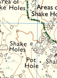
If it’s a solid black line then that denotes and boundary of some sort. Usually a small squire well less than a mm would be a sheep fold. If it’s the one I’m thinking of (see screen shot) in the valley it’s a wall/fence to stop sheep falling into a pot hole.IMG_1067.jpeg
 
Last edited:
  • Like
Reactions: Dan00001
Interesting, I am mostly self taught but have considered taking a course. I have 2 sessions of navigation with MR over the next couple of weeks and I'll be assessed on in towards the end of the year.
I’d say, and not because I sell courses it can be beneficial to do some sort of course. The structure of the NNAS courses is such that it teaches only relevant map and compass skills and strategies of navigation. I have a gold course there beginning of October and happy to discuss if you have questions. DM me is you like.
 
  • Like
Reactions: Dan00001
If it’s a solid black line then that denotes and boundary of some sort. Usually a small squire well less than a mm would be a sheep fold. If it’s the one I’m thinking of (see screen shot) in the valley it’s a wall/fence to stop sheep falling into a pot hole.View attachment 104900
Yes that's the one! Oh that's interesting, as you can see on Google it's shaped like a horseshoe which peaked my interest. Will have to have a look next time.
 

BCUK Shop

We have a a number of knives, T-Shirts and other items for sale.

SHOP HERE