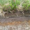
What do you reccon to these soil layers?

Jul 30, 2012
3,570
225
westmidlands
I found these exposed soil layers, quite interesting, 3 layers, current brown layer divided by a small black line, I suppose from the burning of the land, then a very dark brown gray layer and then a sandy gravelly layer. The gravel at the bottom is just the accumulation that falls out of the face
IMG_20180531_104525.jpg

My thoughts where the different land uses over time, grass woodland and glacial.?
 

Robson Valley

On a new journey
Nov 24, 2014
9,959
2,672
McBride, BC
That unsorted gravel layer is what we see in post glacial debris which has not been sorted by flowing water = moraines, that sort of thing.
What's the lay of the land? Flat? Hilly?
Yours is very fine, small stones. Our moraine deposits are junk to the size of old television sets.
Anything left in the black line to indicate charcoal?

Volcanic eruptions in western North America have left ash deposit layers for thousands of miles eastwards.
If it is ash, might even have come from Iceland.
 
  • Like
Reactions: Billy-o

Billy-o

Bushcrafter (boy, I've got a lot to say!)
Apr 19, 2018
2,039
1,027
Canada
Given where it is, could it just be an industrial artefact. Sooty air :)

Sometimes that line is evidence of a change in the water level ... different types of plants leaving a different deposit
 

Toddy

Mod
Mod
Jan 21, 2005
39,133
4,810
S. Lanarkshire
That dark layer looks like flooded land, peaty stuff. Not very deep though, is it ? You do find that kind of colouring sometimes where land has been dug over and organics (manure, old straw, seaweed, etc.,) added in for a year or two. Then left alone and the plants left in peace to root through the upper layers.

It's very precise stratigraphy though, and very definite disparity between the layers.
A scale would be useful, as would an idea of situation.

Is the white gravelly stuff above a chalk matrix perchance ?

Honestly, it looks like wet and dry horizons, but without context :dunno:

Interesting though :)

M
 
Jul 30, 2012
3,570
225
westmidlands
Up the side of a hill, or Mynd as it is, and quite near the top, so it's not flooded, there is peat all around, but to me the black layer is what gets left behind after land clearance. Icealnd is a few miles away, so to leave a deposit of any thickness it would have to be a large eruption, probably epoch ending. The underlying is slatesque rock etc.
 
  • Like
Reactions: Robson Valley

Robson Valley

On a new journey
Nov 24, 2014
9,959
2,672
McBride, BC
Mt Baker (in Washington state) is in the Ring of Fire. It smolders some steam pharts, most of the time.
It blew, about 11,000 years ago. Onshore Pacific airflow at that time.
That's how the Canadian prairies around Regina got a 2" ash layer from the eruption.
That's more than 1,000 miles east. Volcanic ash regularly circles the globe.
 

Toddy

Mod
Mod
Jan 21, 2005
39,133
4,810
S. Lanarkshire
Up the side of a hill, or Mynd as it is, and quite near the top, so it's not flooded, there is peat all around, but to me the black layer is what gets left behind after land clearance. Icealnd is a few miles away, so to leave a deposit of any thickness it would have to be a large eruption, probably epoch ending. The underlying is slatesque rock etc.


Here you go :)
https://en.wikipedia.org/wiki/Longmyndian_Supergroup

Does that ring any bells ?

M
 
  • Like
Reactions: petrochemicals
Jul 30, 2012
3,570
225
westmidlands
Yep that's the area. The fossils from the rock though are far deeper and, well rocky, and the soil will have been there no where near as long. I have looked into it before. All along the area there are ridges like Wenlock Edge and plains inbetween, not your glacial valleys.
 

Toddy

Mod
Mod
Jan 21, 2005
39,133
4,810
S. Lanarkshire
We are taught that the end progression is peat. Everywhere, even in Africa, it'll be peat.....and here in my sodden wet bit of the world even the hills have peat.

Andy's the fellow, he's a Geologist. Thinking on it though, he's not the only one on the forum.
Interesting to hear what one of them makes of it :)

M
 
Jul 30, 2012
3,570
225
westmidlands
We are taught that the end progression is peat. Everywhere, even in Africa, it'll be peat.....and here in my sodden wet bit of the world even the hills have peat.

Andy's the fellow, he's a Geologist. Thinking on it though, he's not the only one on the forum.
Interesting to hear what one of them makes of it :)

M
I did not know that about peat bogs. The mynds are large flat top hills with peat bogs rising high above the valley, some are propper peat bogs that look like land slips and are inpassable, 6ft tall islands of solids with soft swamps inbetween.
 

Toddy

Mod
Mod
Jan 21, 2005
39,133
4,810
S. Lanarkshire
You can get weird layers in situations like that. Leached soils and the like, as well as some where minerals, like iron, end up as bog iron and iron pan. Then if it is exposed it changes as it dries and weathers. If it's flooded and silted over, that'll change it again too.

There's an awful lot more to the layering of the land than volcanic events. In some areas, where single catastrophic events like tsunami waves have deposited massive amounts of marine debris, it can leave even more confusion, especially as that can be quite definitely inland from the shore. Miles inshore in some instances.

I didn't do much geology at Uni, but I admit I did find it, and the maps (the maps are glorious :D) quite fascinating really.

M
 
  • Like
Reactions: Billy-o

BCUK Shop

We have a a number of knives, T-Shirts and other items for sale.

SHOP HERE