For the past few months I have been thinking about possibly doing a winter climb of Mt Washington. I finally decided to just do it. I bought a map of the area, took two days off, and this past weekend I gave it a go.
Just as some background, Mt. Washington is located in New Hampshire, and is the highest point in the eastern United States. Now, that doesnt mean much. The peak rises to 6,288 ft (1,917 m), which is nothing when compared to some of the peaks in the west. As a result, during warmer weather it is a relatively easy climb, turning it, much as other high peaks, into a tourist trap. In fact, during the warmer months there is a road on one side of the mountain that can take people up to the top where there is a weather observatory. I had little interest in climbing a mountain just to see a bus of school children there taking their picture at the top.
The challenge with Mt. Washington is to climb it in winter. When the snow starts coming down, most approaches to the mountain get closed due to avalanche danger. The road certainly shuts down, so the only people on the top are the ones willing to climb up the one route which is typically left open, as it avoids most of the avalanche cones on the slopes. It is called the Lions Head winter route.

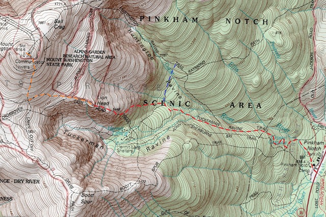
I have marked the route on the map. It starts out at the Pinkham Notch visitors center at the bottom of the mountain at about 2100 ft. From there it follows the Tuckerman Ravine Trail for part of the way. During warmer months this is one of the typical approaches to the top of the mountain. During winter however, most of this trail is closed. The approach takes a detour onto the Lions Head Winter Trail, which takes you up above the tree line. It then passes through the Alpine Garden, and then up to the summit of Mt. Washington. The most common way to make a summit attempt is to do it as a day trip. People usually start out before sunrise, carrying only light day packs, and make a rush on the summit. I didnt want to do that. I wanted the experience to involve me spending at least one night in the woods.
The challenge with a winter summit attempt of Mt. Washington is not the elevation, or even the temperature, which rarely drops below 20F (-29C), but rather the extreme winds that batter the mountain above tree line. In fact, in 1934 the fastest wind on Earth was recorded here, on Mt. Washington of 231 mph (372 km/h). The high winds can cause wind-chill of under 70F (-57C) and can make travel above the tree line impossible.
So, my plan to make the summit attempt was to leave from NY Friday night after work, travel through the night (6.5 hours) so I can be at the base of the mountain Saturday morning. I would then climb up to the top of the tree line where I would set up camp. Then I would have Sunday and Monday to make summit attempts before returning on Tuesday. As luck would have it however, just as Friday approached, the northeast got hit with one of the biggest snow storms we have had all winter. In my are we got three feet of snow Friday afternoon. I tried to get the car out, but it was impossible. Turns out to have been a good thing because the governors of several of the states through which I would have to pass declared a state of emergency and closed all the roads, including the highways.
I waited out the storm, and had to shift my schedule back a day. Unfortunately, that would remove a day from my trip. So, with my local street plowed, I got in the car Saturday night and headed for Mt. Washington. While the travel ban had been lifted, large sections of the highway were not plowed, which meant all the cars had to move in each others tracks at 10 mph. It took me over 10 hours to complete the trip. Around 10am on Sunday I was at the bottom of Mt. Washington at the Pinkham Notch visitors center. Now, before starting the trip, a bit on the gear:

Usually the winter gear you see me using (check last trip report) is designed for temperatures down to 0F (-18C). Its the gear I use the most because that is the typical temperature range for my local woods. What you see above is my really cold weather gear. I dont bring it out too often, and I figured this would be a good time to let it get some air. The main difference between this gear and my usual winter gear is that the sleeping bag has been replaced by the Western Mountaineering Puma (-25F) bag, instead of the Western Mountaineering Antelope (0F) bag. Also, my Patagonia DAS Parka is replaced by the Eddie Bauer Ascent Peak XV down jacket. Sometimes, although not on this trip, I also replace my usual Kovea Spider stove with a MSR Whisperlite white gas stove. All other gear remains the same. Now, all this bulkier gear does not fit in the REI Flash 62 pack. Because of that, I have to transition to the larger Gregory Palisade 80L pack.
I spent a lot of time thinking about whether or not I will be able to get away with my lighter typical winter gear on this trip, but with night time temperatures going as low as 20F (-29C) the week before, I chickened out, and went with the heavier, more comfortable gear. They say that the mark of a true woodsman is not knowing what to bring, but rather what to leave out. Looks like this was an amateur move on my part. The one piece of gear that I almost didn't bring, but I am very glad I did was the snowshoes. They are always a lot of weight to carry around, but with two feet of fresh snow on top of the few feet of snow already on the ground, much of the trip would have been impossible without them.
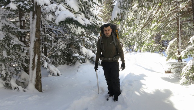
Alright, now that we are done with the gear, I headed out. Even though the temperature was chilly, probably around 5F (-21C), I started out with just my fleece top. Moving in snow uses up a lot of energy and you warm up very fast, especially when you are going up an incline. Traveling along the Tuckerman Ravine Trail was pretty easy. The elevation gain is not great, and the trail is clearly cut in between the trees. Usually it is well traveled because it leads to a few ski slopes, but because of all the snow the previous day, it looked like only a few skiers had gone up this way before me. Around noon I stopped for lunch.

In the picture you see me wearing the Eddie Bauer Ascent Peak XV jacket. It is extremely warm while still being very compressible. I could have probably gotten away with a lighter jacket, but the Peak XV doesnt get out much, and it waned to come out and play. If you are wondering, I am sitting on my snow shoes with the insulating pad on top of them. They kept me from sinking in the soft snow. As far as food, for this trip I had switched to foods I could eat with my gloves on, and that could be cooked without getting my pot dirty. Washing a pot in 10F (-12C) is annoying, washing it at 10F (-23C) is something I avoid at all costs. I brought beef jerky, Cliff bars, and mountain house frozen dinners that you could rehydrate in the packet. I soon discovered that my jaw is not strong enough to chew through enough beef jerky and Cliff bars to give me the calories I needed.
After lunch I decided to put on the snow shoes. In the past I have hated wearing snow shoes, but they would certainly help in the soft snow. I have to say, ever since I got the MSR Lightning Ascent show shoes, every time I put them on, I am amazed by how well they perform. As much as I disliked snowshoeing in the past, I actually love these snow shoes. I used them every chance I got for the rest of the trip.

Now, earlier I mentioned that I was planning on camping somewhere just below the top of the tree line. Unfortunately, when I got to Pinkham Notch, I found out that it would not be possible. Apparently due to avalanche danger, or whatever else, overnighting is not allowed in most places on the mountain. Camping was allowed just about everywhere about a days walk from the mountain, but that didnt do me any good. There are two places on the mountain where camping is allowed. I decided to stay at one of them, called Harvard Cabin. The way they made it sound at Pinkham Notch was as if though it was an actual camp site. You had to pay $10 to use it, and you could either stay at the cabin or the camp site. Each option had very limited numbers allowed. I was very disappointed. If I wanted to go to a camp site, I didn't have to travel 10 hours to do it.
Fortunately however, I was very pleasantly surprised when I go there. I dont know what it looks like during Summer, but this time of year there was no camp site at all. I reached a small cabin. Inside was just a guy, a wood stove, a table and a hammock. It made Dick Proennekes cabin look like a luxury resort.

Other than the cabin there was no camp site at all. Apparently the purpose of these two locations is to limit the number of people who can overnight on the mountain. I think there was a limit of 16 people in this area. Didn't seem to be a problem as I was the only person there. The guy told me to just go either up or down from the cabin, find a location that I liked and set up my camp. Thats exactly what I did; I stamped out an area with my snowshoes and pitched the shelter. To support the center pole I used a piece of tree bark so I wouldn't have to use one of the snow shoes, as I needed them to get just about anywhere.

It was still early, probably about 2pm. I melted a bunch of water, ate some more beef jerky, sat back and relaxed.
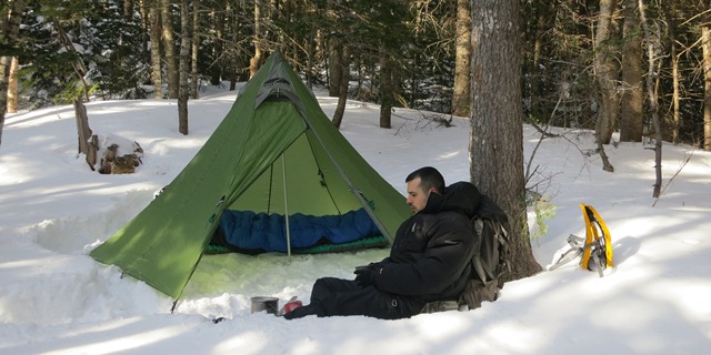
After eating, I pulled my hood up and apparently dozed off. I woke up a bit after 4pm. The sun had gone down behind the mountains and it was noticeably colder. I cooked my dinner, and ate, which warmed me up. The Kovea Spider, even though not designed to work in such low temperatures did just fine. Its only downside when compared to a white gas stove is that it was noticeably slower to melt snow.
I mentioned earlier that this is not my usual winter temperature to camp out in, so each time I do this, I end up learning something new. I already knew not to try to wash my pot because the water would turn into ice and coat the pot before you can wash away any of the food. The new one this time was to be careful with fuel canisters. Usually each time you disconnect the stove some fuel leaks out from the canister. This time, the fuel got on my hand, and instead of turning into liquid, it immediately froze solid. A sharp pain shot up my hand. My first reaction was to take my glove off, but I couldnt do it because it was stuck to my hand. I put it close to my body and let it defrost. Luckily after I removed the glove there wasnt any serious damage. I got some frost nip, and had some pain in the fingers for the rest of the trip, but none of the skin came off. After this problem, I just went to bed. I kept all of my water and electronics inside the sleeping bag.
The night was relatively warm, probably about 10F (-23C). The WM Puma sleeping bag was overkill. At some point in the night though, the winds really picked up. The Shangri-La 3 did great at keeping the wind out. It made a pig difference. It would have been much colder without it. The next morning, I was packed up by 8am, and started on my way up the mountain.
I back tracked to the Lions Hear route, which was quick because the ground was level. I snowshoed the whole distance and part up the Lions Hear route. When it started to get steep, I switched to crampons. Note that I was not climbing with the Peak XV coat on. I just pulled it out and put it on every time I had to stop for a prolonged period of time.
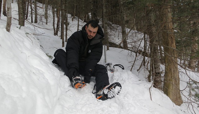
At times the climb was steep and very sketchy. A few times I thought about turning back because if I got injured I would have no way to get out. However, I kept going. I remember seeing a wooden ladder placed on the slope in peoples pictures of their own climbs, but it wasn't there. It was either removed, or it was completely covered by snow. Its fine by me either way. I strongly believe that if you cant do a climb with your own skills and gear you carry with you, then you shouldn't be doing it. As I gained elevation, I started seeing above the trees. I quickly noticed some clouds in the distance that I didn't like.
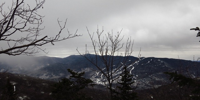
I kept moving up. Little by little, the tracks that I was following up the mountain kept diminishing. By the time I neared the top of the tree line, I counted only three set of tracks ahead of me, judging by the ice axe holes. I reached the top of the tree line just as the clouds caught up with me and it started snowing. I stopped to eat and get some water, as well as put on another insulation layer (the REI Revelcloud) and my shell layer (Arcteryx Beta SV).

It was fairly cold, but I didn't mind it. My biggest worry at this point was the lack of visibility and the strong winds, which seemed to get worse. Here is a screen shot a friend of mine took for me during that time on the mountain.
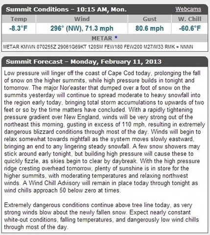
The temperature wasn't bad; 8.3F (-22.4C), but the wind chill was very serious at 60.6F (-51.4C). At that temperature you have to cover all skin to prevent frostbite, and you have to keep moving. Even with very thick clothing, if you stand around, you will freeze. The interesting thing however is that even at these temperatures you can easily overheat when you are climbing. You still need relatively light clothing that would keep you cool when moving. When you stop, then you put on your thick jacket, which you then remove once you start moving again. A warm easily compressible jacket like the Peak XV or the DAS Parka is key to this.

Unfortunately, from this point forward there would be no full self portraits. The wind was just too strong for the camera to not be blown away. As you can see from the above picture, I chose to forego the goggles, which I didn't bring at all, and instead go with my Julbo Explorer glacier glasses. They are much lighter and do a very good job at staying close to your face and preventing snow from getting in your eyes. Unfortunately, just like goggles they fog up very easily, and once you remove them, the condensation freezes solid.
I kept pushing up, but visibility was getting close to zero. The wind was also brutal and I had a very hard time moving.
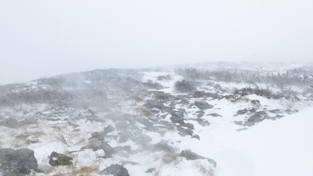


At this point I saw three guys coming down the mountain. Apparently they were the ones whose tracks I had seen going up. They told me that they had left at 5am and had made it past the Alpine Garden when they were caught by the storm. They had to turn away about a mile from the summit because they just could see anything or move in the wind. I told them I would push up a bit further. I went forward for another half hour and realized I had the exact same problem. I couldn't see anything, and moving was almost impossible. I decided to turn back. Just as I was contemplating turning around. I saw two guys trying to make their way up the mountain behind me.
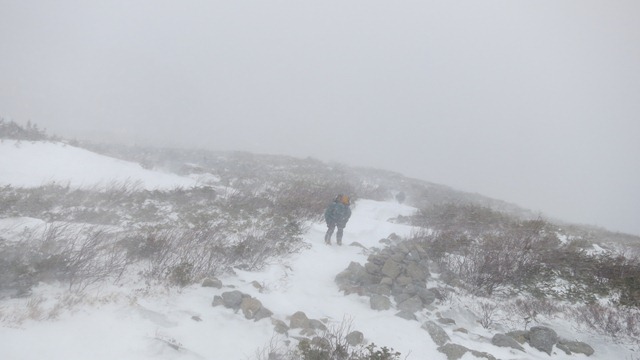
They reached my position. I told them the issues I was having. They said that they will try to go a bit further. I told them that if they were willing to go, I would go with them, so we kept climbing. Eventually we saw the rock formation called Lions Head, after which the trail is named. It is hard to see in the picture below, but it is the rock in the middle of the photo that kind of looks like a lions head.
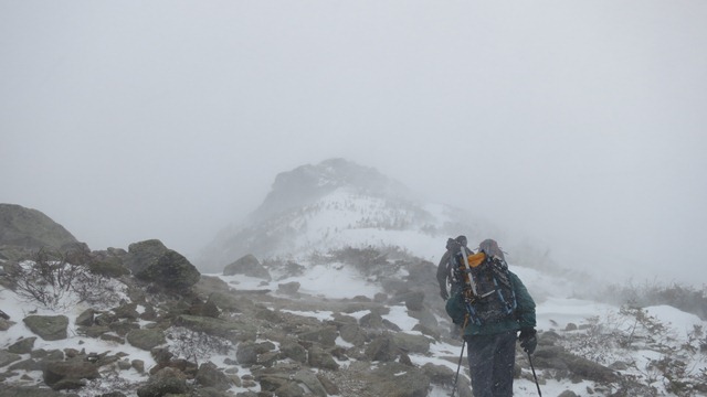
It was becoming literally impossible to move. We just couldn't stand up straight. We would make two steps and then be blown over. At times, no matter how hard you tried to stand up against the wind, it would blow you over. We struggled along, at time crawling until we got part way up Lions Head, just below the Alpine Garden. At that point one of the guys called it. I certainly shared his feeling that we couldn't go on. Even if we found a way to keep moving, we were burning too much energy doing it. It would have been impossible to make it all the way up to Mt. Washington and then back down.

We decided to turn back. I took a picture of myself at this highest point I managed to reach, complete with frozen face and snotcicles.

We made our way down as fast as possible. We all had some serious falls, and I had to self arrest at least a few times. It wasn't easy to do with this powdery snow. The snow was also a large part of the reason we were falling so much. It was just too soft and too deep. The crampons wouldn't penetrate deep enough to drab onto any hard packed snow or ice. You could be knee deep in snow and have the whole two feet of snow sliding down from under you.
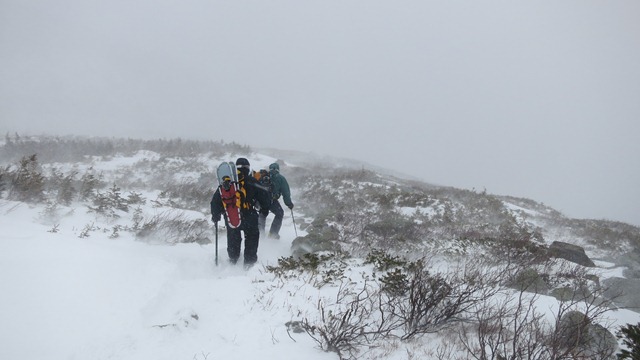
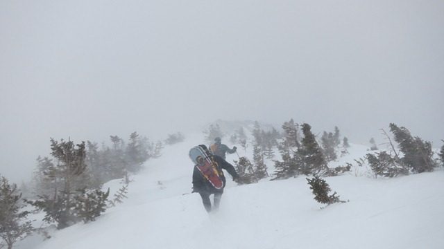
Eventually we made it back to the tree line and some shelter. There we stopped for some food and water.
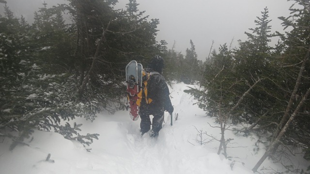
This was unfortunately the last picture I was able to take during the day. I had kept my camera out to take pictures, and it froze. I put it under my clothing to defrost it, but it looks like when the ice melted, the water got into the lens. Its a shame because once we got down the mountain we had some beautiful winter scenery with the softly falling snow. We put on out snowshoes, and made our way down. I went back to Harvard Cabin to spend the night. Since there was no one else there, I got the same spot I had the previous day.
The next day the weather was nice and warm, the snow had stopped, and the camera had dried out. I figured I would take another picture of my camp.
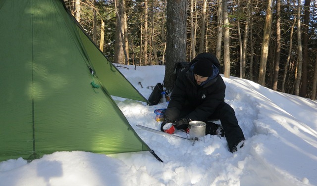
I hadn't eaten my dinner the previous night, opting to just get in the sleeping bag and having some Cliff bars. I cooked it for breakfast instead.
In the morning it was a quick trip down the mountain. I actually put on the clothing I was wearing when climbing the mountain the previous day so you can see a full shot of it. It was obviously way too warm to actually snowshoes out wearing all this clothing.

Unfortunately, my GPS had some issues, so I cant show you the usual pictures. I managed to salvage a picture of the track, but not the elevation. You would have to judge that from the actual map.

It will be easier to see on the actual map below. The red line represents the route that I was planning to follow on the original map above and actually ended up following. The blue line is the detour to Harvard Cabin where I camped out both nights. The yellow line is the uncompleted part of the route.
Even though I failed to reach the summit, I cant say that I am particularly upset. If the weather was better, or if the storm hadn't prevented me from getting to the mountain the previous day, I could have done it, but then again, how often do you get to push yourself against such conditions? It was a great experience and it let me fine tune a few things. Unfortunately because of the long drive this is not something I can do too often, but I will give it another shot, probably next year.
Just as some background, Mt. Washington is located in New Hampshire, and is the highest point in the eastern United States. Now, that doesnt mean much. The peak rises to 6,288 ft (1,917 m), which is nothing when compared to some of the peaks in the west. As a result, during warmer weather it is a relatively easy climb, turning it, much as other high peaks, into a tourist trap. In fact, during the warmer months there is a road on one side of the mountain that can take people up to the top where there is a weather observatory. I had little interest in climbing a mountain just to see a bus of school children there taking their picture at the top.
The challenge with Mt. Washington is to climb it in winter. When the snow starts coming down, most approaches to the mountain get closed due to avalanche danger. The road certainly shuts down, so the only people on the top are the ones willing to climb up the one route which is typically left open, as it avoids most of the avalanche cones on the slopes. It is called the Lions Head winter route.

I have marked the route on the map. It starts out at the Pinkham Notch visitors center at the bottom of the mountain at about 2100 ft. From there it follows the Tuckerman Ravine Trail for part of the way. During warmer months this is one of the typical approaches to the top of the mountain. During winter however, most of this trail is closed. The approach takes a detour onto the Lions Head Winter Trail, which takes you up above the tree line. It then passes through the Alpine Garden, and then up to the summit of Mt. Washington. The most common way to make a summit attempt is to do it as a day trip. People usually start out before sunrise, carrying only light day packs, and make a rush on the summit. I didnt want to do that. I wanted the experience to involve me spending at least one night in the woods.
The challenge with a winter summit attempt of Mt. Washington is not the elevation, or even the temperature, which rarely drops below 20F (-29C), but rather the extreme winds that batter the mountain above tree line. In fact, in 1934 the fastest wind on Earth was recorded here, on Mt. Washington of 231 mph (372 km/h). The high winds can cause wind-chill of under 70F (-57C) and can make travel above the tree line impossible.
So, my plan to make the summit attempt was to leave from NY Friday night after work, travel through the night (6.5 hours) so I can be at the base of the mountain Saturday morning. I would then climb up to the top of the tree line where I would set up camp. Then I would have Sunday and Monday to make summit attempts before returning on Tuesday. As luck would have it however, just as Friday approached, the northeast got hit with one of the biggest snow storms we have had all winter. In my are we got three feet of snow Friday afternoon. I tried to get the car out, but it was impossible. Turns out to have been a good thing because the governors of several of the states through which I would have to pass declared a state of emergency and closed all the roads, including the highways.
I waited out the storm, and had to shift my schedule back a day. Unfortunately, that would remove a day from my trip. So, with my local street plowed, I got in the car Saturday night and headed for Mt. Washington. While the travel ban had been lifted, large sections of the highway were not plowed, which meant all the cars had to move in each others tracks at 10 mph. It took me over 10 hours to complete the trip. Around 10am on Sunday I was at the bottom of Mt. Washington at the Pinkham Notch visitors center. Now, before starting the trip, a bit on the gear:

Usually the winter gear you see me using (check last trip report) is designed for temperatures down to 0F (-18C). Its the gear I use the most because that is the typical temperature range for my local woods. What you see above is my really cold weather gear. I dont bring it out too often, and I figured this would be a good time to let it get some air. The main difference between this gear and my usual winter gear is that the sleeping bag has been replaced by the Western Mountaineering Puma (-25F) bag, instead of the Western Mountaineering Antelope (0F) bag. Also, my Patagonia DAS Parka is replaced by the Eddie Bauer Ascent Peak XV down jacket. Sometimes, although not on this trip, I also replace my usual Kovea Spider stove with a MSR Whisperlite white gas stove. All other gear remains the same. Now, all this bulkier gear does not fit in the REI Flash 62 pack. Because of that, I have to transition to the larger Gregory Palisade 80L pack.
I spent a lot of time thinking about whether or not I will be able to get away with my lighter typical winter gear on this trip, but with night time temperatures going as low as 20F (-29C) the week before, I chickened out, and went with the heavier, more comfortable gear. They say that the mark of a true woodsman is not knowing what to bring, but rather what to leave out. Looks like this was an amateur move on my part. The one piece of gear that I almost didn't bring, but I am very glad I did was the snowshoes. They are always a lot of weight to carry around, but with two feet of fresh snow on top of the few feet of snow already on the ground, much of the trip would have been impossible without them.

Alright, now that we are done with the gear, I headed out. Even though the temperature was chilly, probably around 5F (-21C), I started out with just my fleece top. Moving in snow uses up a lot of energy and you warm up very fast, especially when you are going up an incline. Traveling along the Tuckerman Ravine Trail was pretty easy. The elevation gain is not great, and the trail is clearly cut in between the trees. Usually it is well traveled because it leads to a few ski slopes, but because of all the snow the previous day, it looked like only a few skiers had gone up this way before me. Around noon I stopped for lunch.

In the picture you see me wearing the Eddie Bauer Ascent Peak XV jacket. It is extremely warm while still being very compressible. I could have probably gotten away with a lighter jacket, but the Peak XV doesnt get out much, and it waned to come out and play. If you are wondering, I am sitting on my snow shoes with the insulating pad on top of them. They kept me from sinking in the soft snow. As far as food, for this trip I had switched to foods I could eat with my gloves on, and that could be cooked without getting my pot dirty. Washing a pot in 10F (-12C) is annoying, washing it at 10F (-23C) is something I avoid at all costs. I brought beef jerky, Cliff bars, and mountain house frozen dinners that you could rehydrate in the packet. I soon discovered that my jaw is not strong enough to chew through enough beef jerky and Cliff bars to give me the calories I needed.
After lunch I decided to put on the snow shoes. In the past I have hated wearing snow shoes, but they would certainly help in the soft snow. I have to say, ever since I got the MSR Lightning Ascent show shoes, every time I put them on, I am amazed by how well they perform. As much as I disliked snowshoeing in the past, I actually love these snow shoes. I used them every chance I got for the rest of the trip.

Now, earlier I mentioned that I was planning on camping somewhere just below the top of the tree line. Unfortunately, when I got to Pinkham Notch, I found out that it would not be possible. Apparently due to avalanche danger, or whatever else, overnighting is not allowed in most places on the mountain. Camping was allowed just about everywhere about a days walk from the mountain, but that didnt do me any good. There are two places on the mountain where camping is allowed. I decided to stay at one of them, called Harvard Cabin. The way they made it sound at Pinkham Notch was as if though it was an actual camp site. You had to pay $10 to use it, and you could either stay at the cabin or the camp site. Each option had very limited numbers allowed. I was very disappointed. If I wanted to go to a camp site, I didn't have to travel 10 hours to do it.
Fortunately however, I was very pleasantly surprised when I go there. I dont know what it looks like during Summer, but this time of year there was no camp site at all. I reached a small cabin. Inside was just a guy, a wood stove, a table and a hammock. It made Dick Proennekes cabin look like a luxury resort.

Other than the cabin there was no camp site at all. Apparently the purpose of these two locations is to limit the number of people who can overnight on the mountain. I think there was a limit of 16 people in this area. Didn't seem to be a problem as I was the only person there. The guy told me to just go either up or down from the cabin, find a location that I liked and set up my camp. Thats exactly what I did; I stamped out an area with my snowshoes and pitched the shelter. To support the center pole I used a piece of tree bark so I wouldn't have to use one of the snow shoes, as I needed them to get just about anywhere.

It was still early, probably about 2pm. I melted a bunch of water, ate some more beef jerky, sat back and relaxed.

After eating, I pulled my hood up and apparently dozed off. I woke up a bit after 4pm. The sun had gone down behind the mountains and it was noticeably colder. I cooked my dinner, and ate, which warmed me up. The Kovea Spider, even though not designed to work in such low temperatures did just fine. Its only downside when compared to a white gas stove is that it was noticeably slower to melt snow.
I mentioned earlier that this is not my usual winter temperature to camp out in, so each time I do this, I end up learning something new. I already knew not to try to wash my pot because the water would turn into ice and coat the pot before you can wash away any of the food. The new one this time was to be careful with fuel canisters. Usually each time you disconnect the stove some fuel leaks out from the canister. This time, the fuel got on my hand, and instead of turning into liquid, it immediately froze solid. A sharp pain shot up my hand. My first reaction was to take my glove off, but I couldnt do it because it was stuck to my hand. I put it close to my body and let it defrost. Luckily after I removed the glove there wasnt any serious damage. I got some frost nip, and had some pain in the fingers for the rest of the trip, but none of the skin came off. After this problem, I just went to bed. I kept all of my water and electronics inside the sleeping bag.
The night was relatively warm, probably about 10F (-23C). The WM Puma sleeping bag was overkill. At some point in the night though, the winds really picked up. The Shangri-La 3 did great at keeping the wind out. It made a pig difference. It would have been much colder without it. The next morning, I was packed up by 8am, and started on my way up the mountain.
I back tracked to the Lions Hear route, which was quick because the ground was level. I snowshoed the whole distance and part up the Lions Hear route. When it started to get steep, I switched to crampons. Note that I was not climbing with the Peak XV coat on. I just pulled it out and put it on every time I had to stop for a prolonged period of time.

At times the climb was steep and very sketchy. A few times I thought about turning back because if I got injured I would have no way to get out. However, I kept going. I remember seeing a wooden ladder placed on the slope in peoples pictures of their own climbs, but it wasn't there. It was either removed, or it was completely covered by snow. Its fine by me either way. I strongly believe that if you cant do a climb with your own skills and gear you carry with you, then you shouldn't be doing it. As I gained elevation, I started seeing above the trees. I quickly noticed some clouds in the distance that I didn't like.

I kept moving up. Little by little, the tracks that I was following up the mountain kept diminishing. By the time I neared the top of the tree line, I counted only three set of tracks ahead of me, judging by the ice axe holes. I reached the top of the tree line just as the clouds caught up with me and it started snowing. I stopped to eat and get some water, as well as put on another insulation layer (the REI Revelcloud) and my shell layer (Arcteryx Beta SV).

It was fairly cold, but I didn't mind it. My biggest worry at this point was the lack of visibility and the strong winds, which seemed to get worse. Here is a screen shot a friend of mine took for me during that time on the mountain.

The temperature wasn't bad; 8.3F (-22.4C), but the wind chill was very serious at 60.6F (-51.4C). At that temperature you have to cover all skin to prevent frostbite, and you have to keep moving. Even with very thick clothing, if you stand around, you will freeze. The interesting thing however is that even at these temperatures you can easily overheat when you are climbing. You still need relatively light clothing that would keep you cool when moving. When you stop, then you put on your thick jacket, which you then remove once you start moving again. A warm easily compressible jacket like the Peak XV or the DAS Parka is key to this.

Unfortunately, from this point forward there would be no full self portraits. The wind was just too strong for the camera to not be blown away. As you can see from the above picture, I chose to forego the goggles, which I didn't bring at all, and instead go with my Julbo Explorer glacier glasses. They are much lighter and do a very good job at staying close to your face and preventing snow from getting in your eyes. Unfortunately, just like goggles they fog up very easily, and once you remove them, the condensation freezes solid.
I kept pushing up, but visibility was getting close to zero. The wind was also brutal and I had a very hard time moving.


At this point I saw three guys coming down the mountain. Apparently they were the ones whose tracks I had seen going up. They told me that they had left at 5am and had made it past the Alpine Garden when they were caught by the storm. They had to turn away about a mile from the summit because they just could see anything or move in the wind. I told them I would push up a bit further. I went forward for another half hour and realized I had the exact same problem. I couldn't see anything, and moving was almost impossible. I decided to turn back. Just as I was contemplating turning around. I saw two guys trying to make their way up the mountain behind me.

They reached my position. I told them the issues I was having. They said that they will try to go a bit further. I told them that if they were willing to go, I would go with them, so we kept climbing. Eventually we saw the rock formation called Lions Head, after which the trail is named. It is hard to see in the picture below, but it is the rock in the middle of the photo that kind of looks like a lions head.

It was becoming literally impossible to move. We just couldn't stand up straight. We would make two steps and then be blown over. At times, no matter how hard you tried to stand up against the wind, it would blow you over. We struggled along, at time crawling until we got part way up Lions Head, just below the Alpine Garden. At that point one of the guys called it. I certainly shared his feeling that we couldn't go on. Even if we found a way to keep moving, we were burning too much energy doing it. It would have been impossible to make it all the way up to Mt. Washington and then back down.

We decided to turn back. I took a picture of myself at this highest point I managed to reach, complete with frozen face and snotcicles.

We made our way down as fast as possible. We all had some serious falls, and I had to self arrest at least a few times. It wasn't easy to do with this powdery snow. The snow was also a large part of the reason we were falling so much. It was just too soft and too deep. The crampons wouldn't penetrate deep enough to drab onto any hard packed snow or ice. You could be knee deep in snow and have the whole two feet of snow sliding down from under you.


Eventually we made it back to the tree line and some shelter. There we stopped for some food and water.

This was unfortunately the last picture I was able to take during the day. I had kept my camera out to take pictures, and it froze. I put it under my clothing to defrost it, but it looks like when the ice melted, the water got into the lens. Its a shame because once we got down the mountain we had some beautiful winter scenery with the softly falling snow. We put on out snowshoes, and made our way down. I went back to Harvard Cabin to spend the night. Since there was no one else there, I got the same spot I had the previous day.
The next day the weather was nice and warm, the snow had stopped, and the camera had dried out. I figured I would take another picture of my camp.

I hadn't eaten my dinner the previous night, opting to just get in the sleeping bag and having some Cliff bars. I cooked it for breakfast instead.
In the morning it was a quick trip down the mountain. I actually put on the clothing I was wearing when climbing the mountain the previous day so you can see a full shot of it. It was obviously way too warm to actually snowshoes out wearing all this clothing.

Unfortunately, my GPS had some issues, so I cant show you the usual pictures. I managed to salvage a picture of the track, but not the elevation. You would have to judge that from the actual map.

It will be easier to see on the actual map below. The red line represents the route that I was planning to follow on the original map above and actually ended up following. The blue line is the detour to Harvard Cabin where I camped out both nights. The yellow line is the uncompleted part of the route.

Even though I failed to reach the summit, I cant say that I am particularly upset. If the weather was better, or if the storm hadn't prevented me from getting to the mountain the previous day, I could have done it, but then again, how often do you get to push yourself against such conditions? It was a great experience and it let me fine tune a few things. Unfortunately because of the long drive this is not something I can do too often, but I will give it another shot, probably next year.
