I have been playing about with an App from the AppStore called QCT Viewer, which allows you to display maps from MemoryMap on the iPhone, so I thought I would share it with the members here. It costs a £5 and is a faily basic App which lists the maps that you have loaded on the iPhone & can work out which one (or more than one if you have different scales e.g. OS 25K & 50K). It uses the GPS on my iPhone 3G (& presumably on the 3GS as well) to locate where youy are on the map. It has speed & heading details, but those are not to clear as they are in red text on a grey background.
It does crash every once in a while, usually while loading but once it's all loaded & the GPS has locked then it's quite useable. It's better on OS 25K maps, rather than 50K ones, as you can zoom in enough for it to be useful. It was written by a guy who uses the Areonautical maps, which is why the zoom is a bit limited on low res maps. The map display rotates when you turn the phone round, which is cool in that iPhone sort of way, but the main menu does not rotate, which is OK as you dont see it most of the time.
As for maps, it loads the idividual file that you are currently on, which is not that big an area if you are on an OS25K map; it's good for walking but not so good if you use it in the car & cross onto the next map. You can stitch maps togeather in the PC version of MM, which is what I have done for the local maps I have. It did not like a file of 550Mb but is OK with those around 100Mb a piece, which is usable.
To get maps onto the iPhone there is a Java based server app that is OK but will stop/crash if the files are too big. For those who have broken out of jail,then you just find the apps folder in /private/var/mobile/applications/<long number here> then copy the maps into the Documents folder, using something like iPhone Browser.
I have no connection with the company etc.., am just a happy user. Apparently they have sorted any legal/copyright issues out, as the QCT files are apparently an open format even though the MemoryMap files are licensed.
All in all I am pretty happy with it as it does what I want, which is to show me where I am when I get lost in a wood. There are no waypoints, route planning etc.. like you get on the Windows Mobile MM but it still works fine.
As I said it's now on the Apple AppStore & the website is here:
http://millermilngavie.f2s.com/qctviewer/QCTViewer/QCTViewer_for_iPhone.html
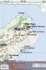
I have included a picture the map display to give you an idea of what it looks like. It has not been out long & I have a feeling it may disapear of the App store, so it may be worth getting a copy soon if MM take offence to it.
It does crash every once in a while, usually while loading but once it's all loaded & the GPS has locked then it's quite useable. It's better on OS 25K maps, rather than 50K ones, as you can zoom in enough for it to be useful. It was written by a guy who uses the Areonautical maps, which is why the zoom is a bit limited on low res maps. The map display rotates when you turn the phone round, which is cool in that iPhone sort of way, but the main menu does not rotate, which is OK as you dont see it most of the time.
As for maps, it loads the idividual file that you are currently on, which is not that big an area if you are on an OS25K map; it's good for walking but not so good if you use it in the car & cross onto the next map. You can stitch maps togeather in the PC version of MM, which is what I have done for the local maps I have. It did not like a file of 550Mb but is OK with those around 100Mb a piece, which is usable.
To get maps onto the iPhone there is a Java based server app that is OK but will stop/crash if the files are too big. For those who have broken out of jail,then you just find the apps folder in /private/var/mobile/applications/<long number here> then copy the maps into the Documents folder, using something like iPhone Browser.
I have no connection with the company etc.., am just a happy user. Apparently they have sorted any legal/copyright issues out, as the QCT files are apparently an open format even though the MemoryMap files are licensed.
All in all I am pretty happy with it as it does what I want, which is to show me where I am when I get lost in a wood. There are no waypoints, route planning etc.. like you get on the Windows Mobile MM but it still works fine.
As I said it's now on the Apple AppStore & the website is here:
http://millermilngavie.f2s.com/qctviewer/QCTViewer/QCTViewer_for_iPhone.html
I have included a picture the map display to give you an idea of what it looks like. It has not been out long & I have a feeling it may disapear of the App store, so it may be worth getting a copy soon if MM take offence to it.