There is a sinister Dutchman sitting at this table writing. The pen scratching over the paper as I stare impassively at my phone waiting for twitter to update.
A gust of wind, a thunder clap, the windows shake. We both look up at the windows, rain streaming down them in sheets.
I'm sat in the common room of a Youth Hostel somewhere in the German speaking part of Eastern Belgium. I'm waiting for a friend who's flying in from Oman to rescue me. I'm not supposed to be here. This isn't how this adventure was supposed to turn out.
Day 1 - Getting high.
Collectively Luxembourg, Belgium and the Netherlands are known as the low countries. Mention them and people tend to picture the polder landscapes of the west, the beautiful architecture of Ghent, and the strong dark beers of Rochefort. But look at a map, and you notice that it's not all flat earth. The eastern side of the BeNeLux is marked by an area of hills, The Ardennes. They are predominantly in Belgium and Luxembourg, but stretch into Germany and France. I had to be in Wiltz for the Linux Bier Wanderung, so as I was going to be in the area, decided to turn up a few days early and have a bit of a cycle tour. Looking at the map It occured to me that the highest points of the three countries, Kneiff (560masl), Signal de Botange (694masl) and Valserberg (322masl) form a neat line 66.4km from north to south. That's cycling distance. A plan formed.
Starting from where my previous Luxembourg cycle adventure started, in Wiltz, I would cycle north to the three high points of the three BeNeLux countries, then hang a right to Aachen for a train back to Wiltz. I played around with route planners and maps, and eventually I had a rough route plan. 123km total distance, over 3 days with a total ascent of 1719m. This split into 3 sections, Wiltz to Kneiff - 36.6km, Kneiff to Signal de Botange - 51km, Signal de Botange to Valserberg - 35.5km. Even better the elevation graph showed that from Signal de Botange to Valserberg was basically 30km of down hill. I loaded my Brompton with kit for a bivvi, 3 days food, a pile of maps (three for Belgium, 2 for Luxembourg). And left for the Eurostar.
Tuesday was spent travelling via Eurostar and train to Luxembourg city. I spent the evening there, exploring a bit and finding a rather novel cycle path with a spiral stair case on it (I hope sustrans don't get any ideas...). Then on Wednesday morning I took the train from Luxembourg station North towards Wiltz.
I had tried to find a bike shop in Luxembourg city so I could buy a bike bottle, I'd discovered to my disgust that the bottle I had bought with me had gone a bit manky and wasn't something I wanted to drink from, even after putting a puritab through it. I texted a friend in Belgium via my inReach asking for UTM coordinates of some bike shops in Luxembourg. Turns out that there are more bike shops in the Canterbury postcode than there are in the whole of Luxembourg... looking at the options it seemed the most accessible would be to get off at Mersch, and do the 5k round trip to the bike shop at Rollingen.
Brief bike shop visit including asking them to pump my tyres up, complete with using fingers to show what pressure, and I returned to the station for the train journey to Wiltz with a nice clean new bottle, as well as a free bottle of water the bike shop insisted on giving me.
Changing trains with a fully loaded Brompton at Kautenbach was a less than pleasant experience. It seems that Luxembourg hasn't quite realised that the point of a railway platform is to get you upto the height of the train, rather than a small step to get you on the bottom rung of a ladder to climb into the train...
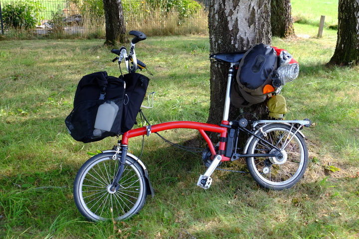
-- Fully Loaded Brompton
Eventually I arrived in Wiltz, and headed to Camping Kaul where I was staying for the Linux Bier Wanderung, and had arranged to leave the baggage I didn't need for my cycle trip. I quick bite to eat in their Bistro, and I hit the road.
I needed to pick up some meths for my stove, so I swung by the local supermarket. They sold 1L bottles of the stuff, but were out of stock at the time. I decided I'd try at the next town with a shop... I didn't realise the that I wouldn't see another shop until the following day in Sankt Vith.
Leaving the supermarket I headed out of town. It was a beautiful sunny day and Europe basked in a heat wave. I was full of enthusiasm for the ride ahead of me and followed the GPS trace past the local brewery, up the hill.
I knew this hill was here, I was expecting it. It showed as an almost vertical cliff on the elevation graph (due to compression of the X axis). But I wasn't quite prepared for it. I dropped down the gears to first, and continued to pedal. I managed about 200m of horizontal distance before I had reached the limits of the gearing. I got off and pushed.
-- Day 1 elevation graph.
One foot in front of the other I plodded up the hill, the sun beating down on me. There was no shade. I stopped after a couple km in the shade of a barn to have a drink and let my temperature drop. I may be cooking, but I was feeling good. Temperature back down to normalish, I continued up the hill to Noertrange. Another water stop in a convenient bus shelter, then back on the bike. The major climb was over and I was on what should be a plateaux. It had taken me 45 minutes to cover just 2.3km. Now I should finally be able to start riding and put distance under my belt.
Leaving Noertrange I entered an area of woodland. The shade was welcome, but the gradient wasn't. Rather than push, I took a 5 minute break to enjoy the scenery. Before continuing onwards.
-- Climbing out of Noertrange
Past Derenbach, onwards to Allerborn. In the fields around me various bits of agricultural machinery toiled away reaping the harvest of golden cereal crops that stretched out on all sides. In one field the wind had kicked up the dust and chaff into spinning vortexes.
The route here went down hill slightly, being able to freewheel down the hill was wonderful, but back in my mind I knew that every metre I went down, I would just have to claw back later.
I left the metalled road at Allerborn and followed a track up hill towards Troine Route. On this ascent a ache in my feet progressed into pain and onwards through towards excruciating. I pulled over in the shade of some birch trees at Troine-Route and took my shoes and socks off. There was no obvious signs of what would be causing the pain. Then I touched my feet. Turns out I had just discovered what it feels like to try cooking your own limbs while still attached. Not something I would recommend. I put the socks into my bag, so much for cool in summer...

-- Letting my feet cool down in the shade of some Birch trees
Cooling down in the shade of the stand of silver birch, I studied the map. Here my planned route was a deviation west towards the Belgian border, before swinging east to Troine. Looking up from the map towards the direction of travel. I looked down on Belgium. Hmmm. I studied the map some more, comparing spot hikes in the area. If I was to stand any chance in this heat I was going to have to adapt. I decided to deviate from my route and head on the main road to Troine. This should cut some ascent as well as maybe shortening my journey by half a k or so.
I didn't regret the decision, I managed to clear some distance quickly passing Troine I headed North for Belgium.
I crossed the border at about 17km into my trip. 2 hours 42 minutes after I had left Wiltz. There are signs either side of the road marking the border between Luxembourg and Belgium, but you don't really need them. You can tell that you've crossed border by the state of the road. Gone was the beautiful smooth tarmac, replaced by the pot hole slalom towards Buret.
Just over 1km into Belgium I turned right onto a disused railway that has been turned into a cycle path. It's marked on my map as RAVel. By choosing a disused railway I hoped that it's relative flatness would allow me to cover some distance. Oh my misguided foolishness.
Yes railways don't have steep inclines, no they have have long slow laborious gradients. False flat. It looks flat, until you start to ride it. But it was better than the steep hills I had been slogging up so I took the opportunity to get my head down and pedal some. I averaged about 22kph on this section, peaking at over 30kph at one point.
My planned route involved turning off the railway line just outside Limerlé. This is where I found the slight error in my map work. Sure the railway line crossed the road at this point. But not at the same height. This wasn't a level crossing, this was a bridge. And there was no easy way to get from it to the road. I'd just have to continue on along the railway line until I found a way off. This blunder added about 3km to my journey.
I left the railway and climbed up towards Hautbellair. Somewhere around here I finished the last of the water. It had been over 34°C during the afternoon, and I was starting to get hot. I needed water. A need that was growing in urgency as I went on.
Every field of livestock I passed I looked to see if I could get water from the trough. Not one that I passed had an accessible valve, and quite a few were clearly filled not off a pipe but by the farmer from a bowser. Every stream marked on my map was dried up. The one I did find was next to a field that showed very obvious signs of recently being treated with Glyphosphate.
My map showed a stream in the woods just North of Goedange. Maybe I could fill up from this.
As I headed towards Goedange the climb started, 110m over 2km. The first symptoms of hyperthermia were starting to show. I started to look everywhere for water, eyeing up every puddle, trying to weigh the risk vs reward of trying to filter it.
At the 35k mark my planned route took me off East to join the Vennrad cycle route. But when I got to the turning, it was impassable. I continued North East towards the main road at Knauf. If I didn't find something to drink soon I was going to be in trouble. In my befuggled mind I tried to run over the options. Could this be grounds to hit the SOS function on my inReach? Was I going to give myself Heat stroke? As I left the woods a few hundred meters before Knauf I saw a building. I would stop there and ask for water, I had to. As I pushed closer the building came into focus. This wasn't just any building. This was a bar. No wait, a restaurant. WATER!
I pulled up at the restaurant, and hobbled upto the bar a pair of empty water pouches in hand.
"Wasser, Aqua, Water." Proffering them the pouches to fill. As one bartender filled my pouches I turned to another and asked for a Fanta. He handed me the bottle and the glass. I downed the bottle and asked for another. He gave me a slightly strange look and handed me another bottle. Two full pouches, and a bottle of Fanta in hand, I hobbled over to a table and collapsed into a seat.
Status check. As I sat rehydrating, I ran my mind over my condition. I couldn't remember the symptoms of hyperthermia, so resorted to googling them. I ran through the symptoms. Heavy sweating. Check. Rapid breathing. Check. Fast weak pulse. I tried to take my radial pulse. Nothing. I switched to the other arm. Nothing. I switched to the carotid. There, something. It's there. But it's feint. And it's fast. I drank some more.
I texted a friend back in the UK updating on my situation. Before I arrived in the bar, I'd drunk over 5L of water. Yet I hadn't pee'd in over 6 hours. Getting out of the sun and rehydrating, my mind started to clear. I ordered another Fanta and tried to regain my composure. The text exchange with the friend helped me decide that I would rest here until just before sunset (about an hour after arriving), then go find somewhere to bivvi down, then decide on onwards travel in the morning.
Having drunk a over a litre since arriving at the pub, I was finally able visit the loo. This added another confirmation of my dehydration, but reassured me that my body was at least able to process what I was pouring in the top.
Fifteen minutes before sunset and with a 3.8L of water in my pouches/bottles, I hit the bike for the final kilometre to Kneiff.
With the sun below the horizon, in the cool twilight of a summers evening, I arrived at the highest point of Luxembourg. A nondescript concrete marker on the edge of a field. I'd done it. One down two to go. Right, bivvi time.
-- The plough over Kneiff
I looked around. On one side a field of maize stretched into the distance, next to that an already harvested wheat field. On the other side of the track a large grass pasture and a few hundred yards down the track, woodland.
I cycled over to the woodland hoping it would present a bivvi opportunity. It was a dense plantation of pine trees, hardly ideal bivvi territory. I looked around. On the other side of the grass field there was a small copse. That might do the trick.
I pushed the Brompton across the lush pasture towards the copse. It was a mix of pine and oak 50m from a larger plot of woodland. In it's lee side there was a slight depression. This would give me shelter from view of anyone on the track. Yes, This is it, this is perfect.
I sat down to drink and listen. As I did I looked up at the sky and watched a light speed across the sky. My first thought was it was the ISS, but that wasn't right, that wasn't for another hour. I had printed out the ISS pass times for my trip, and checked them. Yep, an hours time. Wait what time zone are these in. Ah yeah, that was the ISS, these times are UK time, not EU time. Oops. At least I had seen it.
-- If you look carefully, to the left of centre you can see the trace of a Persied meteor.
I rolled out the bivvi bag, inflated my sleep mat, and lay on top of it staring at the sky. My body temp was normal, my pulse was normal. I was starting to feel good. I nibble on a biscuit. I couldn't cook the meal I had with me as I hadn't found any fuel. As I lay there one by one the stars came out. Blazing across the sky the many camp fires of the hunters who go before. As my eyes adjust, more stars become visible. With full darkness I see for the first time with my own naked eye The Milky Way. I let out an audible wow when I realise what it is I am seeing. I then spent the next hour trying to get a photograph of the sky. Not content with the million star view, the persieds joined the party shooting across the sky towards their firey climax in the upper atmosphere. Happy that I had got some shots that almost did justice to the view, I crawled into my bivvi bag and drifted off to sleep watching persieds shooting across the milky way.
-- The view from my bivvi bag
Day 2 - Bordering on insanity
I woke the next morning hot. Really warm. Too Warm. That wasn't right. I wasn't even moving how can this be? I stuck my head out the bivvi bag and was blinded by the sun. Ah, yeah, that would do it. The sun had crested the trees and I was now laying in full sun. I rolled myself and my bed across into the shade of the trees and lay back. The starlit view of the previous night was now a clear blue sky above a lush green pasture flanked by woodland.
-- The view I woke to.[/caption]
I spread my bedding out in the sunshine to air, and sat in the shade of a tree eating biscuits and pondering the plan. Yesterday had been just 38km. Todays plan was 51km. Not just further, but also higher. If the heat was the same as yesterday would I be able to do it?
I looked at the map. From here to Sankt Vith is just over 20km, and by the looks of it it should be mostly downhill. I will pay later for each metre of descent. But at least I should be eating up some distance.
I packed the bike, and hit the road. The first couple of km would be descent to join the Vennrad cycle route along a disused railway. Due to particularities of political geography the trackbed of the Vennrad is in Belgium along it's whole length, but large sections of it run through Germany creating all sorts of exclaves and counter exclaves.
Crossing into Belgium I descended down a long sweeping track, hitting 37kph as I headed for the turn onto the cycle route. The 90° turn. The 90° turn was compounded by a small collection of mamil's loitering on the corner blocking the only path that would allow any useful speed carry through the corner. I cursed, and hammered the brakes to bring my speed down and coast past the mamils onto the Vennrad with a cheery "Morgan".
After the open shadeless scenery of the previous day a track through the dappled shade of woodland was a welcome change. The route tended downwards for the first 12km, past idylic farmsteads, pasture and woodland. After a few km I stopped at an information board which had some information of the history of the Venn Bahn. There were some Dutch cyclists there trying to work out where they were and where they were going. They didn't have a map, so I pulled mine out and helped them work out where they were and where they wanted to go. Between my broken Dutch and their broken English, we chatted about our rides before bidding each other Goede Reis and departing in opposite directions.
The 12km of downhill came to and abrupt end in Germany. Only I didn't realise it was Germany at first. I stopped in a bus shelter to have a drink and some more biscuits. I was trying to work out where I was when I noticed the design of the postbox opposite. That was most definitely a Deutschepost logo. Quick GPS check, yep I'm in Hemmeres, Germany. Which used to be Belgian before it was returned in 1958.
I crossed back into Belgium and begun the long dragging ascent towards Sankt Vith. Passed beautiful river side meadows, tree covered hillsides and pastures of livestock. Past scout camps, villages and farmsteads. I plodded on. Even in the shade of the trees there was no escaping the heat. It was't quite as bad as yesterday, but was still enough to leave my body covered in a near constant sheen of sweat. Somewhere short of Sankt Vith I ran out of water again.
Nearing Breitfeld things started to take on a more built up appearance with an elevated motorway. It was near here that I saw a Slow Worm slinking it's way across the hot tarmac.
Two and a half hours, and 26km after leaving my Bivvi site, I coasted into Sankt Vith. I pulled up at a bar on the site of the old train station. Ordering a brace of drinks and requestion refills of my water pouches, I sat in the shade and pondered my options. It was about 1300, and I was hot and sore. I'd managed about half the days distance, but hadn't got to the main ascents of the day. Even with every container I had on me I didn't seem to be able to carry enough water to cycle in this heat, and so far places to refill had been rather few and far between.
I pondered my options. Go on, risk further dehydration and heat exhaustion? If I bailed here what were my options? I pulled out my phone to see where the nearest youth hostel was. Two kilometres away. That sealed it. I booked a bed for the night from my phone, paid my tab, and slowly rode up the hill to the hostel.
Which finds me sat in a Youth hostel, in German speaking Belgium with a Sinister Dutchman scribbling away across the table. I'd set out to cycle 123km, I'd managed 64. I've had to bail out due to high temperatures, dehydration and the first stages of Heat Exhaustion. In Belgium. This really is bordering on insanity...
A gust of wind, a thunder clap, the windows shake. We both look up at the windows, rain streaming down them in sheets.
I'm sat in the common room of a Youth Hostel somewhere in the German speaking part of Eastern Belgium. I'm waiting for a friend who's flying in from Oman to rescue me. I'm not supposed to be here. This isn't how this adventure was supposed to turn out.
Day 1 - Getting high.
Collectively Luxembourg, Belgium and the Netherlands are known as the low countries. Mention them and people tend to picture the polder landscapes of the west, the beautiful architecture of Ghent, and the strong dark beers of Rochefort. But look at a map, and you notice that it's not all flat earth. The eastern side of the BeNeLux is marked by an area of hills, The Ardennes. They are predominantly in Belgium and Luxembourg, but stretch into Germany and France. I had to be in Wiltz for the Linux Bier Wanderung, so as I was going to be in the area, decided to turn up a few days early and have a bit of a cycle tour. Looking at the map It occured to me that the highest points of the three countries, Kneiff (560masl), Signal de Botange (694masl) and Valserberg (322masl) form a neat line 66.4km from north to south. That's cycling distance. A plan formed.
Starting from where my previous Luxembourg cycle adventure started, in Wiltz, I would cycle north to the three high points of the three BeNeLux countries, then hang a right to Aachen for a train back to Wiltz. I played around with route planners and maps, and eventually I had a rough route plan. 123km total distance, over 3 days with a total ascent of 1719m. This split into 3 sections, Wiltz to Kneiff - 36.6km, Kneiff to Signal de Botange - 51km, Signal de Botange to Valserberg - 35.5km. Even better the elevation graph showed that from Signal de Botange to Valserberg was basically 30km of down hill. I loaded my Brompton with kit for a bivvi, 3 days food, a pile of maps (three for Belgium, 2 for Luxembourg). And left for the Eurostar.
Tuesday was spent travelling via Eurostar and train to Luxembourg city. I spent the evening there, exploring a bit and finding a rather novel cycle path with a spiral stair case on it (I hope sustrans don't get any ideas...). Then on Wednesday morning I took the train from Luxembourg station North towards Wiltz.
I had tried to find a bike shop in Luxembourg city so I could buy a bike bottle, I'd discovered to my disgust that the bottle I had bought with me had gone a bit manky and wasn't something I wanted to drink from, even after putting a puritab through it. I texted a friend in Belgium via my inReach asking for UTM coordinates of some bike shops in Luxembourg. Turns out that there are more bike shops in the Canterbury postcode than there are in the whole of Luxembourg... looking at the options it seemed the most accessible would be to get off at Mersch, and do the 5k round trip to the bike shop at Rollingen.
Brief bike shop visit including asking them to pump my tyres up, complete with using fingers to show what pressure, and I returned to the station for the train journey to Wiltz with a nice clean new bottle, as well as a free bottle of water the bike shop insisted on giving me.
Changing trains with a fully loaded Brompton at Kautenbach was a less than pleasant experience. It seems that Luxembourg hasn't quite realised that the point of a railway platform is to get you upto the height of the train, rather than a small step to get you on the bottom rung of a ladder to climb into the train...
-- Fully Loaded Brompton
Eventually I arrived in Wiltz, and headed to Camping Kaul where I was staying for the Linux Bier Wanderung, and had arranged to leave the baggage I didn't need for my cycle trip. I quick bite to eat in their Bistro, and I hit the road.
I needed to pick up some meths for my stove, so I swung by the local supermarket. They sold 1L bottles of the stuff, but were out of stock at the time. I decided I'd try at the next town with a shop... I didn't realise the that I wouldn't see another shop until the following day in Sankt Vith.
Leaving the supermarket I headed out of town. It was a beautiful sunny day and Europe basked in a heat wave. I was full of enthusiasm for the ride ahead of me and followed the GPS trace past the local brewery, up the hill.
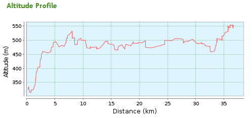
I knew this hill was here, I was expecting it. It showed as an almost vertical cliff on the elevation graph (due to compression of the X axis). But I wasn't quite prepared for it. I dropped down the gears to first, and continued to pedal. I managed about 200m of horizontal distance before I had reached the limits of the gearing. I got off and pushed.
-- Day 1 elevation graph.
One foot in front of the other I plodded up the hill, the sun beating down on me. There was no shade. I stopped after a couple km in the shade of a barn to have a drink and let my temperature drop. I may be cooking, but I was feeling good. Temperature back down to normalish, I continued up the hill to Noertrange. Another water stop in a convenient bus shelter, then back on the bike. The major climb was over and I was on what should be a plateaux. It had taken me 45 minutes to cover just 2.3km. Now I should finally be able to start riding and put distance under my belt.
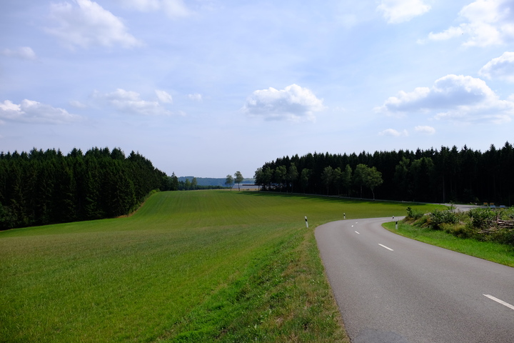
Leaving Noertrange I entered an area of woodland. The shade was welcome, but the gradient wasn't. Rather than push, I took a 5 minute break to enjoy the scenery. Before continuing onwards.
-- Climbing out of Noertrange
Past Derenbach, onwards to Allerborn. In the fields around me various bits of agricultural machinery toiled away reaping the harvest of golden cereal crops that stretched out on all sides. In one field the wind had kicked up the dust and chaff into spinning vortexes.
The route here went down hill slightly, being able to freewheel down the hill was wonderful, but back in my mind I knew that every metre I went down, I would just have to claw back later.
I left the metalled road at Allerborn and followed a track up hill towards Troine Route. On this ascent a ache in my feet progressed into pain and onwards through towards excruciating. I pulled over in the shade of some birch trees at Troine-Route and took my shoes and socks off. There was no obvious signs of what would be causing the pain. Then I touched my feet. Turns out I had just discovered what it feels like to try cooking your own limbs while still attached. Not something I would recommend. I put the socks into my bag, so much for cool in summer...
-- Letting my feet cool down in the shade of some Birch trees
Cooling down in the shade of the stand of silver birch, I studied the map. Here my planned route was a deviation west towards the Belgian border, before swinging east to Troine. Looking up from the map towards the direction of travel. I looked down on Belgium. Hmmm. I studied the map some more, comparing spot hikes in the area. If I was to stand any chance in this heat I was going to have to adapt. I decided to deviate from my route and head on the main road to Troine. This should cut some ascent as well as maybe shortening my journey by half a k or so.
I didn't regret the decision, I managed to clear some distance quickly passing Troine I headed North for Belgium.
I crossed the border at about 17km into my trip. 2 hours 42 minutes after I had left Wiltz. There are signs either side of the road marking the border between Luxembourg and Belgium, but you don't really need them. You can tell that you've crossed border by the state of the road. Gone was the beautiful smooth tarmac, replaced by the pot hole slalom towards Buret.
Just over 1km into Belgium I turned right onto a disused railway that has been turned into a cycle path. It's marked on my map as RAVel. By choosing a disused railway I hoped that it's relative flatness would allow me to cover some distance. Oh my misguided foolishness.
Yes railways don't have steep inclines, no they have have long slow laborious gradients. False flat. It looks flat, until you start to ride it. But it was better than the steep hills I had been slogging up so I took the opportunity to get my head down and pedal some. I averaged about 22kph on this section, peaking at over 30kph at one point.
My planned route involved turning off the railway line just outside Limerlé. This is where I found the slight error in my map work. Sure the railway line crossed the road at this point. But not at the same height. This wasn't a level crossing, this was a bridge. And there was no easy way to get from it to the road. I'd just have to continue on along the railway line until I found a way off. This blunder added about 3km to my journey.
I left the railway and climbed up towards Hautbellair. Somewhere around here I finished the last of the water. It had been over 34°C during the afternoon, and I was starting to get hot. I needed water. A need that was growing in urgency as I went on.
Every field of livestock I passed I looked to see if I could get water from the trough. Not one that I passed had an accessible valve, and quite a few were clearly filled not off a pipe but by the farmer from a bowser. Every stream marked on my map was dried up. The one I did find was next to a field that showed very obvious signs of recently being treated with Glyphosphate.
My map showed a stream in the woods just North of Goedange. Maybe I could fill up from this.
As I headed towards Goedange the climb started, 110m over 2km. The first symptoms of hyperthermia were starting to show. I started to look everywhere for water, eyeing up every puddle, trying to weigh the risk vs reward of trying to filter it.
At the 35k mark my planned route took me off East to join the Vennrad cycle route. But when I got to the turning, it was impassable. I continued North East towards the main road at Knauf. If I didn't find something to drink soon I was going to be in trouble. In my befuggled mind I tried to run over the options. Could this be grounds to hit the SOS function on my inReach? Was I going to give myself Heat stroke? As I left the woods a few hundred meters before Knauf I saw a building. I would stop there and ask for water, I had to. As I pushed closer the building came into focus. This wasn't just any building. This was a bar. No wait, a restaurant. WATER!
I pulled up at the restaurant, and hobbled upto the bar a pair of empty water pouches in hand.
"Wasser, Aqua, Water." Proffering them the pouches to fill. As one bartender filled my pouches I turned to another and asked for a Fanta. He handed me the bottle and the glass. I downed the bottle and asked for another. He gave me a slightly strange look and handed me another bottle. Two full pouches, and a bottle of Fanta in hand, I hobbled over to a table and collapsed into a seat.
Status check. As I sat rehydrating, I ran my mind over my condition. I couldn't remember the symptoms of hyperthermia, so resorted to googling them. I ran through the symptoms. Heavy sweating. Check. Rapid breathing. Check. Fast weak pulse. I tried to take my radial pulse. Nothing. I switched to the other arm. Nothing. I switched to the carotid. There, something. It's there. But it's feint. And it's fast. I drank some more.
I texted a friend back in the UK updating on my situation. Before I arrived in the bar, I'd drunk over 5L of water. Yet I hadn't pee'd in over 6 hours. Getting out of the sun and rehydrating, my mind started to clear. I ordered another Fanta and tried to regain my composure. The text exchange with the friend helped me decide that I would rest here until just before sunset (about an hour after arriving), then go find somewhere to bivvi down, then decide on onwards travel in the morning.
Having drunk a over a litre since arriving at the pub, I was finally able visit the loo. This added another confirmation of my dehydration, but reassured me that my body was at least able to process what I was pouring in the top.
Fifteen minutes before sunset and with a 3.8L of water in my pouches/bottles, I hit the bike for the final kilometre to Kneiff.
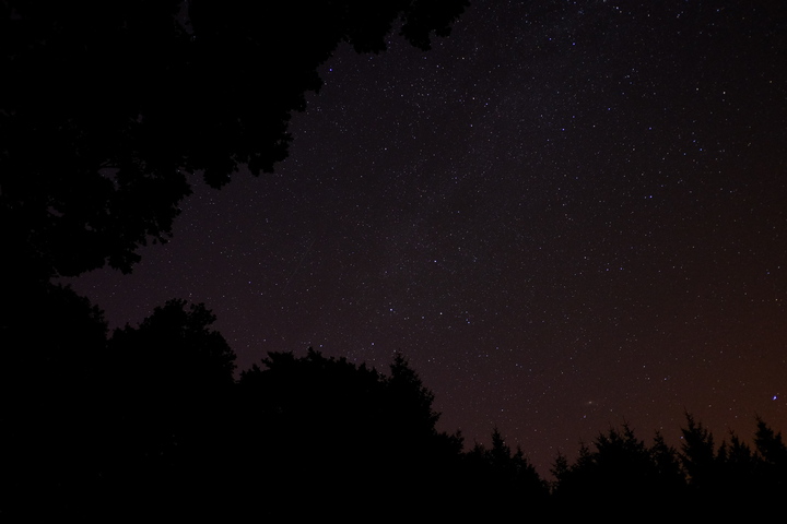
With the sun below the horizon, in the cool twilight of a summers evening, I arrived at the highest point of Luxembourg. A nondescript concrete marker on the edge of a field. I'd done it. One down two to go. Right, bivvi time.
-- The plough over Kneiff
I looked around. On one side a field of maize stretched into the distance, next to that an already harvested wheat field. On the other side of the track a large grass pasture and a few hundred yards down the track, woodland.
I cycled over to the woodland hoping it would present a bivvi opportunity. It was a dense plantation of pine trees, hardly ideal bivvi territory. I looked around. On the other side of the grass field there was a small copse. That might do the trick.
I pushed the Brompton across the lush pasture towards the copse. It was a mix of pine and oak 50m from a larger plot of woodland. In it's lee side there was a slight depression. This would give me shelter from view of anyone on the track. Yes, This is it, this is perfect.
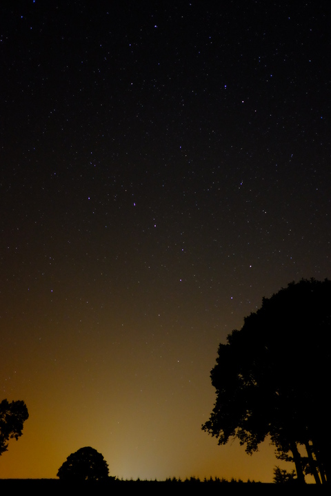
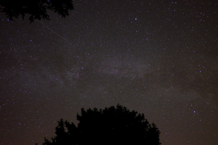
I sat down to drink and listen. As I did I looked up at the sky and watched a light speed across the sky. My first thought was it was the ISS, but that wasn't right, that wasn't for another hour. I had printed out the ISS pass times for my trip, and checked them. Yep, an hours time. Wait what time zone are these in. Ah yeah, that was the ISS, these times are UK time, not EU time. Oops. At least I had seen it.
-- If you look carefully, to the left of centre you can see the trace of a Persied meteor.
I rolled out the bivvi bag, inflated my sleep mat, and lay on top of it staring at the sky. My body temp was normal, my pulse was normal. I was starting to feel good. I nibble on a biscuit. I couldn't cook the meal I had with me as I hadn't found any fuel. As I lay there one by one the stars came out. Blazing across the sky the many camp fires of the hunters who go before. As my eyes adjust, more stars become visible. With full darkness I see for the first time with my own naked eye The Milky Way. I let out an audible wow when I realise what it is I am seeing. I then spent the next hour trying to get a photograph of the sky. Not content with the million star view, the persieds joined the party shooting across the sky towards their firey climax in the upper atmosphere. Happy that I had got some shots that almost did justice to the view, I crawled into my bivvi bag and drifted off to sleep watching persieds shooting across the milky way.
-- The view from my bivvi bag
Day 2 - Bordering on insanity
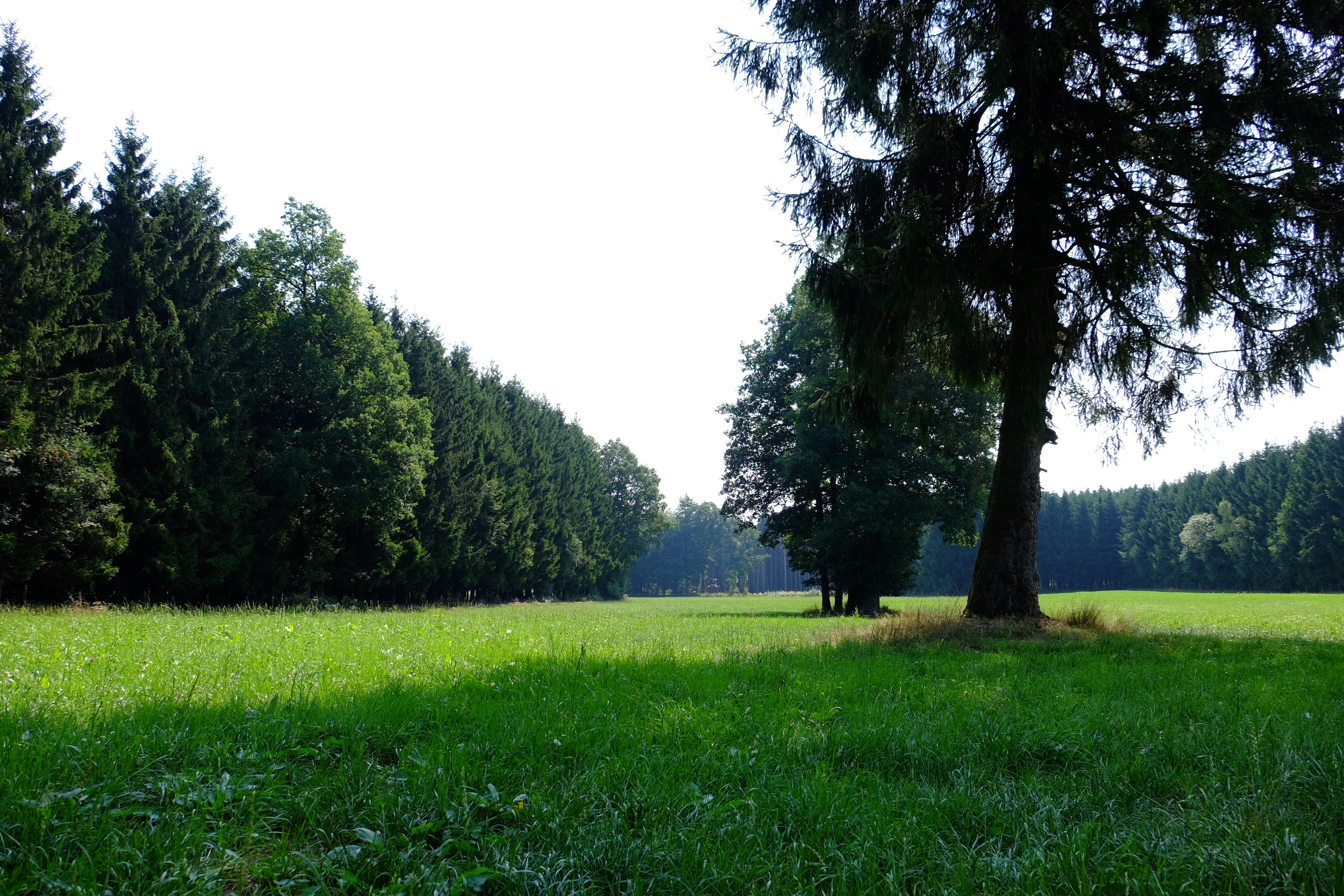
I woke the next morning hot. Really warm. Too Warm. That wasn't right. I wasn't even moving how can this be? I stuck my head out the bivvi bag and was blinded by the sun. Ah, yeah, that would do it. The sun had crested the trees and I was now laying in full sun. I rolled myself and my bed across into the shade of the trees and lay back. The starlit view of the previous night was now a clear blue sky above a lush green pasture flanked by woodland.
-- The view I woke to.[/caption]
I spread my bedding out in the sunshine to air, and sat in the shade of a tree eating biscuits and pondering the plan. Yesterday had been just 38km. Todays plan was 51km. Not just further, but also higher. If the heat was the same as yesterday would I be able to do it?
I looked at the map. From here to Sankt Vith is just over 20km, and by the looks of it it should be mostly downhill. I will pay later for each metre of descent. But at least I should be eating up some distance.
I packed the bike, and hit the road. The first couple of km would be descent to join the Vennrad cycle route along a disused railway. Due to particularities of political geography the trackbed of the Vennrad is in Belgium along it's whole length, but large sections of it run through Germany creating all sorts of exclaves and counter exclaves.
Crossing into Belgium I descended down a long sweeping track, hitting 37kph as I headed for the turn onto the cycle route. The 90° turn. The 90° turn was compounded by a small collection of mamil's loitering on the corner blocking the only path that would allow any useful speed carry through the corner. I cursed, and hammered the brakes to bring my speed down and coast past the mamils onto the Vennrad with a cheery "Morgan".
After the open shadeless scenery of the previous day a track through the dappled shade of woodland was a welcome change. The route tended downwards for the first 12km, past idylic farmsteads, pasture and woodland. After a few km I stopped at an information board which had some information of the history of the Venn Bahn. There were some Dutch cyclists there trying to work out where they were and where they were going. They didn't have a map, so I pulled mine out and helped them work out where they were and where they wanted to go. Between my broken Dutch and their broken English, we chatted about our rides before bidding each other Goede Reis and departing in opposite directions.
The 12km of downhill came to and abrupt end in Germany. Only I didn't realise it was Germany at first. I stopped in a bus shelter to have a drink and some more biscuits. I was trying to work out where I was when I noticed the design of the postbox opposite. That was most definitely a Deutschepost logo. Quick GPS check, yep I'm in Hemmeres, Germany. Which used to be Belgian before it was returned in 1958.
I crossed back into Belgium and begun the long dragging ascent towards Sankt Vith. Passed beautiful river side meadows, tree covered hillsides and pastures of livestock. Past scout camps, villages and farmsteads. I plodded on. Even in the shade of the trees there was no escaping the heat. It was't quite as bad as yesterday, but was still enough to leave my body covered in a near constant sheen of sweat. Somewhere short of Sankt Vith I ran out of water again.
Nearing Breitfeld things started to take on a more built up appearance with an elevated motorway. It was near here that I saw a Slow Worm slinking it's way across the hot tarmac.
Two and a half hours, and 26km after leaving my Bivvi site, I coasted into Sankt Vith. I pulled up at a bar on the site of the old train station. Ordering a brace of drinks and requestion refills of my water pouches, I sat in the shade and pondered my options. It was about 1300, and I was hot and sore. I'd managed about half the days distance, but hadn't got to the main ascents of the day. Even with every container I had on me I didn't seem to be able to carry enough water to cycle in this heat, and so far places to refill had been rather few and far between.
I pondered my options. Go on, risk further dehydration and heat exhaustion? If I bailed here what were my options? I pulled out my phone to see where the nearest youth hostel was. Two kilometres away. That sealed it. I booked a bed for the night from my phone, paid my tab, and slowly rode up the hill to the hostel.
Which finds me sat in a Youth hostel, in German speaking Belgium with a Sinister Dutchman scribbling away across the table. I'd set out to cycle 123km, I'd managed 64. I've had to bail out due to high temperatures, dehydration and the first stages of Heat Exhaustion. In Belgium. This really is bordering on insanity...
")