Biker, Happy Joan of Arc Day!

Jul 30, 2012
3,570
224
westmidlands
Yes it was the young sherlock holmes.

Intresting about the two guns, and brings to memory about arms races "soon they will build bigger guns". The photo is like something out of a cartoon, a really really huge gun sticking out of a hill side.

Also gb took the plunge and bought the spyglass.

This may be a bit more modern for you, although it's only 18cm long the magnification may be a bit hard to keep still.

Edit

Forgot the link
http://www.ebay.co.uk/itm/181169257150
 
Last edited:

Goatboy

Full Member
Jan 31, 2005
14,956
18
Scotland
Yes it was the young sherlock holmes.

Intresting about the two guns, and brings to memory about arms races "soon they will build bigger guns". The photo is like something out of a cartoon, a really really huge gun sticking out of a hill side.

Also gb took the plunge and bought the spyglass.

This may be a bit more modern for you, although it's only 18cm long the magnification may be a bit hard to keep still.

Edit

Forgot the link
http://www.ebay.co.uk/itm/181169257150
[/QUOTE] Oh that looks nice Pedro, ...our husband, I would drink it.[/FONT][/COLOR]
 

Goatboy

Full Member
Jan 31, 2005
14,956
18
Scotland
Pa! Big Bangs in History!

640px-Krakatoa_eruption_lithograph.jpg


No silly we're not alking of old episodes of the big bang theory, we're talking about Krakatoa, which on this day in 1883 explodes with a force of 1,300 megatons and kills approximately 40,000 people.

The 1883 eruption of Krakatoa in the Dutch East Indies (now Indonesia) began on August 26, 1883 (with origins as early as May of that year) and culminated with several destructive eruptions of the remaining caldera. On August 27, two thirds of Krakatoa collapsed in a chain of titanic explosions, destroying most of the island and its surrounding archipelago. Additional alleged seismic activity continued to be reported until February 1884, though reports of those after October 1883 were later dismissed by Rogier Verbeek's investigation. It was one of the deadliest and most destructive volcanic events in recorded history, with at least 36,417 deaths being attributed to the eruption itself and the tsunamis it created. Significant additional effects were also felt around the world.

In the years before the 1883 eruption, seismic activity around the volcano was intense, with earthquakes felt as far away as Australia. Beginning 20 May 1883, steam venting began to occur regularly from Perboewatan, the northernmost of the island's three cones. Eruptions of ash reached an estimated altitude of 6 km (20,000 ft) and explosions could be heard in New Batavia (Jakarta) 160 km (99 mi) away. Activity died down by the end of May, and there was no further recorded activity for several weeks.


Eruptions started again around 16 June, featuring loud explosions and covering the islands with a thick black cloud for five days. On 24 June, a prevailing east wind cleared the cloud, and two ash columns were seen issuing from Krakatoa. The seat of the eruption is believed to have been a new vent or vents which formed between Perboewatan and Danan. The violence of the ongoing eruptions caused tides in the vicinity to be unusually high, and ships at anchor had to be moored with chains as a result. Earthquake shocks began to be felt at Anyer, West Java, and ships began to report large pumice masses appearing in the Indian Ocean to the west.


On 11 August, a Dutch topographical engineer, Captain H. J. G. Ferzenaar, investigated the islands. He noted three major ash columns (the newer from Danan), which obscured the western part of the island, and steam plumes from at least eleven other vents, mostly between Danan and Rakata. When he landed, he noted an ash layer about 0.5 m (1 ft 8 in) thick, and the destruction of all vegetation, leaving only tree stumps. He advised against any further landings. The next day, a ship passing to the north reported a new vent "only a few meters above sea level." (This may be the most northerly spot indicated on Ferzenaar's map.) Activity continued through mid-August.
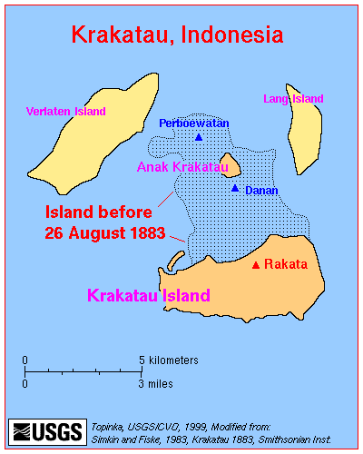
Map_krakatau.gif

By 25 August, eruptions further intensified. At about 13:00 (local time) on 26 August, the volcano went into its paroxysmal phase. By 14:00 observers could see a black cloud of ash 27 km (17 mi) high. At this point, the eruption was virtually continuous and explosions could be heard every ten minutes or so. Ships within 20 km (12 mi) of the volcano reported heavy ash fall, with pieces of hot pumice up to 10 cm (3.9 in) in diameter landing on their decks. A small tsunami hit the shores of Java and Sumatra, some 40 km (25 mi) away, between the time of 18:00 and 19:00 hours.


On 27 August four enormous explosions took place at 05:30, 06:44, 10:02, and 10:41 local time. At 5:30 A.M, the first explosion was at Perboewatan volcano, triggering a tsunami heading straight to Telok Betong. At 6:44 A.M, Krakatoa exploded again on Danan volcano, with the resulting tsunami stretching eastward and westward. The largest explosion, at 10:02 A.M, was so violent that it was heard 3,110 km (1,930 mi) away in Perth, Western Australia, and the Indian Ocean island of Rodrigues near Mauritius (4,800 km (3,000 mi) away), where they were thought to be cannon fire from a nearby ship. Each explosion was accompanied by large tsunamis, which are believed to have been over 30 meters (98 feet) high in places. A large area of the Sunda Strait and a number of places on the Sumatran coast were affected by pyroclastic flows from the volcano. The energy released from the explosion has been estimated to be equal to about 200 megatons of TNT, roughly four times as powerful as the Tsar Bomba (the most powerful thermonuclear weapon ever detonated). At 10:41 A.M, a landslide tore off half of Rakata volcano, causing the final explosion.

The pressure wave generated by the colossal fourth and final explosion radiated out from Krakatoa at 1,086 km/h (675 mph). It was so powerful that it ruptured the eardrums of sailors on ships in the Sunda Strait, and caused a spike of more than 2½ inches of mercury (ca 85 hPa) in pressure gauges attached to gasometers in the Batavia gasworks, sending them off the scale. The pressure wave radiated across the globe and was recorded on barographs all over the world, which continued to register it up to 5 days after the explosion. Barographic recordings show that the shock wave from the final explosion reverberated around the globe 7 times in total. Ash was propelled to an estimated height of 80 km (50 mi).


The eruptions diminished rapidly after that point, and by the morning of 28 August, Krakatoa was silent. Small eruptions, mostly of mud, continued into October 1883.

Around noon on 27 August 1883, a rain of hot ash fell around Ketimbang (now Katibung in Lampung Province) in Sumatra. Approximately 1,000 people were killed, the only large number of victims killed by Krakatoa itself, and not by the waves or after effects. Verbeek, and later writers, believe this unique event was a lateral blast, or pyroclastic surge (similar to the catastrophic 1980 eruption of Mount St. Helens), which crossed the water. The region of the ash fall ended to the northeast of Ketimbang, where the bulk of Sebesi Island offered protection from any horizontal surges.

The combination of pyroclastic flows, volcanic ash, and tsunamis had disastrous results in the region. There were no survivors from the 3,000 people located on the island of Sebesi, about 13 km (8.1 mi) from Krakatoa. Pyroclastic flows killed around 1,000 people at Ketimbang on the coast of Sumatra some 48 km (30 mi) north from Krakatoa. The official death toll recorded by the Dutch authorities was 36,417, although some sources put the estimate at 120,000 or more. Many settlements were destroyed, including Teluk Betung Sirik and Serang in Java. The areas of Banten on Java and the Lampung on Sumatra were devastated. There are numerous documented reports of groups of human skeletons floating across the Indian Ocean on rafts of volcanic pumice and washing up on the east coast of Africa, up to a year after the eruption. Some land on Java was never repopulated; it reverted to jungle, and is now the Ujung Kulon National Park.

Ships as far away as South Africa rocked as tsunamis hit them, and the bodies of victims were found floating in the ocean for months after the event. The tsunamis which accompanied the eruption are believed to have been caused by gigantic pyroclastic flows entering the sea; each of the four great explosions was accompanied by massive pyroclastic flows resulting from the gravitational collapse of the eruption columns. This caused several cubic kilometers of material to enter the sea, displacing an equally huge volume of seawater. The town of Merak was destroyed by a tsunami 46 m (151 ft) high. Some of the pyroclastic flows reached the Sumatran coast as much as 40 km (25 mi) away, having apparently moved across the water on a cushion of superheated steam.[note 2] There are also indications of submarine pyroclastic flows reaching 15 km (9.3 mi) from the volcano.


Smaller waves were recorded on tidal gauges as far away as the English Channel. These occurred too soon to be remnants of the initial tsunamis, and may have been caused by concussive air waves from the eruption. These air waves circled the globe several times and were still detectable on barographs five days later.

In the aftermath of the eruption, it was found that the island of Krakatoa had almost entirely disappeared, except for the southern third. The Rakata cone was cut off along a vertical cliff, leaving behind a 250-metre (820 ft) deep caldera. Of the northern two thirds of the island, only a rocky islet named Bootsmansrots ('Bosun's Rock'), a fragment of Danan, was left; Poolsche Hoed had totally disappeared.


As a result of the huge amount of material deposited by the volcano, the surrounding ocean floor was drastically altered. It is estimated that as much as 18–21 km3 (4.3–5.0 cu mi) of ignimbrite was deposited over an area of 1,100,000 km2 (420,000 sq mi), largely filling the 30–40 m (98–131 ft) deep basin around the mountain. The land masses of Verlaten and Lang islands were increased, as was the western part of the remnant of Rakata. Much of this gained material quickly eroded away, but volcanic ash continues to be a significant part of the geological composition of these islands.


Two nearby sandbanks (called Steers and Calmeyer after the two naval officers who investigated them) were built up into islands by ashfall, but the sea later washed them away. Seawater on hot volcanic deposits on Steers and Calmeyer had caused steam to rise, which some mistook for a continued eruption.


Jul 30, 2012
3,570
224
westmidlands
You havn't done this to scare us over Iceland have you? Because if that goes it will be those on the coast of scotland and Ireland, and thoes up the Clyde (admittedly Iceland will go through another population decrease first) who'll get hit. Not down here on the English plateau.

Also, being as you wrote it was the one of the four explosions 4 times bigger than the Tsar bomb(totalling 16 times for the entire eruption)or all 4 explosions as big as a Tsar bomb each and the total eruption 4 times a tsar bomb?
 

Goatboy

Full Member
Jan 31, 2005
14,956
18
Scotland
You havn't done this to scare us over Iceland have you? Because if that goes it will be those on the coast of scotland and Ireland, and thoes up the Clyde (admittedly Iceland will go through another population decrease first) who'll get hit. Not down here on the English plateau.

Also, being as you wrote it was the one of the four explosions 4 times bigger than the Tsar bomb(totalling 16 times for the entire eruption)or all 4 explosions as big as a Tsar bomb each and the total eruption 4 times a tsar bomb?

The Tsar Bomb was a biggy...

Tsar Bomba ("Emperor Bomb", Tsar being derived from Caesar) is the nickname for the AN602 hydrogen bomb, the most powerful nuclear weapon ever detonated. Its October 30, 1961 test remains the most powerful artificial explosion in human history. It was also referred to as Kuz'kina Mat' (Russian: Кузькина мать, Kuzka's mother), referring to Nikita Khrushchev's promise to show the United States a "Kuz'kina Mat'" at the 1960 United Nations General Assembly. Developed by the Soviet Union, the bomb had the yield of 50 to 58 megatons of TNT (210 to 240 PJ). Only one bomb of this type was ever officially built and it was tested on October 30, 1961, in the Novaya Zemlya archipelago, at Sukhoy Nos.


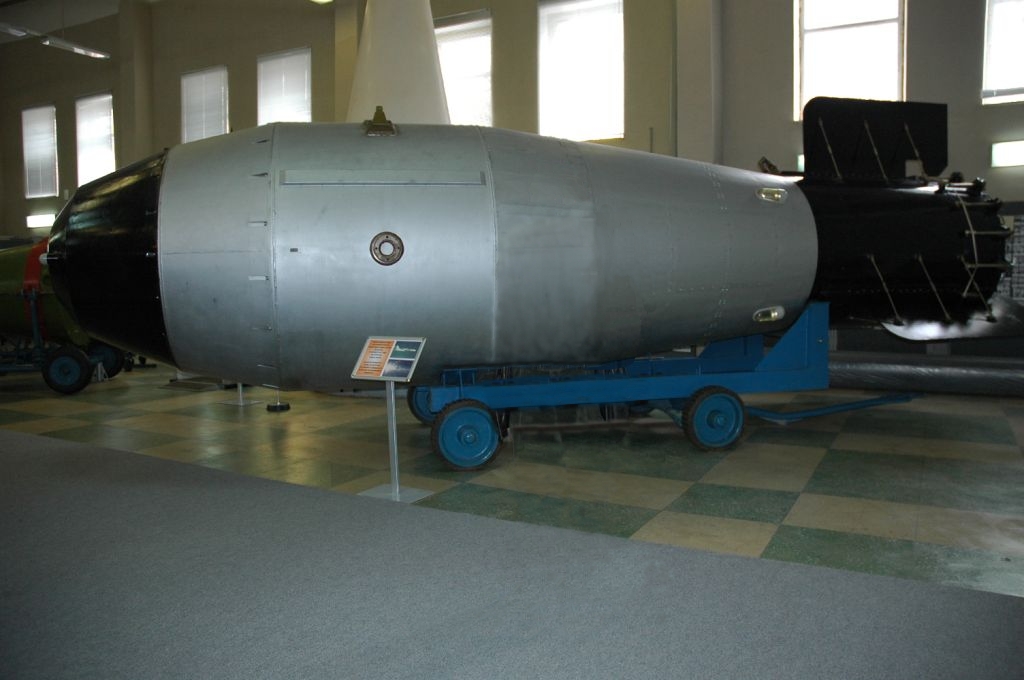
The remaining bomb casings are located at the Russian Atomic Weapon Museum, Sarov (Arzamas-16), and the Museum of Nuclear Weapons, All-Russian Research Institute of Technical Physics, Snezhinsk (Chelyabinsk-70). Neither of these casings has the same antenna configuration as the device that was tested.


Many names are attributed to the Tsar Bomba in the literature: Project 7000; product code 202 (Izdeliye 202); article designations RDS-220 (РДС-220), RDS-202 (РДС-202), RN202 (PH202), AN602 (AH602); codename Vanya; nicknames Big Ivan, Tsar Bomba, Kuz'kina Mat'. The term "Tsar Bomba" was coined in an analogy with two other massive Russian objects: the Tsar Kolokol (Tsar Bell) and the Tsar Pushka (Tsar Cannon). The CIA designated the test as "JOE 111"

Tsar_Bomba_Revised.jpg

A Tsar Bomba-type casing on display at Sarov

Tsar01.jpg

The Tsar Bomba's fireball, about 8 kilometers (5.0 mi) in diameter, was prevented from touching the ground by the shock wave, but nearly reached the 10.5 kilometers (6.5 mi) altitude of the deploying Tu-95 bomber.

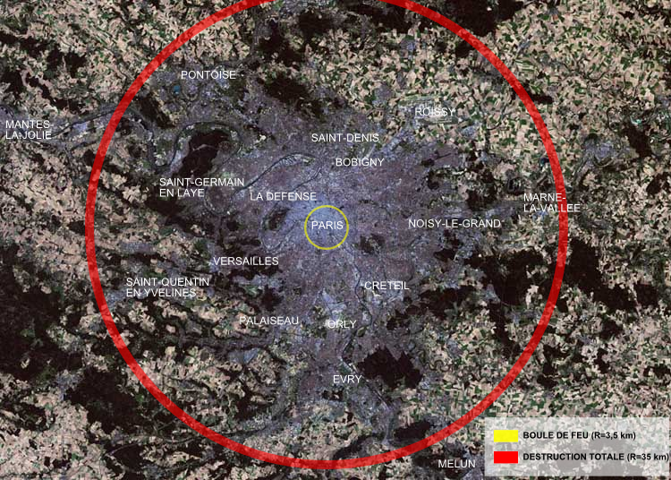
Tsar_Bomba_Paris.png

Zone of total destruction of the Tsar Bomba (as an example – over a map of Paris): red circle = total destruction (radius 35 kilometers (22 mi)), yellow circle = fireball (radius 3.5 kilometers (2.2 mi)).
 

Goatboy

Full Member
Jan 31, 2005
14,956
18
Scotland
[video=youtube;CJY9cOBv5c0]https://www.youtube.com/watch?v=CJY9cOBv5c0[/video]

Hmm, that looked and sounded good. Luckily I'd just had a baked tattie with butter, cheese, ham, fresh milled pepper and homemade beetroot chutney for lunch or I'd have been licking the screen.
 

Goatboy

Full Member
Jan 31, 2005
14,956
18
Scotland
Friend sent me this and thought it was quite funny...

[video=youtube;vBmvfW7WOUc]https://www.youtube.com/watch?v=vBmvfW7WOUc[/video]
 
Jul 30, 2012
3,570
224
westmidlands
Eruption Of Laki

Laki
Laki or Lakagígar (Craters of Laki) is a volcanic fissure situated in the south of Iceland, not far from the canyon of Eldgjá and the small village Kirkjubæjarklaustur, in South-East Iceland. Lakagígar is the correct name as the Laki mountain itself did not erupt, but fissures opened up on each side of it. Lakagígar is part of a volcanic system, centering on the Grímsvötn volcano and including the Thórdarhyrna volcano. It lies between the glaciers of Mýrdalsjökull and Vatnajökull, in an area of fissures which run in a south-west to north-east direction.
The system erupted over an 8 month period during 1783-1784 from the Laki fissure and the adjoining Grímsvötn volcano, pouring out an estimated 14 km3 (3.4 cu mi) of basalt lava and clouds of poisonous hydrofluoric acid/sulfur-dioxide compounds that killed over 50% of Iceland's livestock population, leading to famine which killed approximately 25% of the population.
The Laki eruption and its aftermath has been estimated to have killed over six million people globally, making it the deadliest volcanic eruption in historical times. The drop in temperatures, due to the sulfuric dioxide gases spewed into the northern hemisphere, caused crop failures in Europe, droughts in India, and Japan's worst famine.
 
1783 eruption
On 8 June 1783, a fissure with 130 craters opened with phreatomagmatic explosions because of the groundwater interacting with the rising basalt magma. Over a few days the eruptions became less explosive, Strombolian, and later Hawaiian in character, with high rates of lava effusion. This event is rated as VEI 6 on the Volcanic Explosivity Index, but the eight month emission of sulfuric aerosols resulted in one of the most important climatic and socially repercussive events of the last millennium.
The eruption, also known as the Skaftáreldar ("Skaftá fires") or Síðueldur, produced an estimated 14 km3 (3.4 cu mi) of basalt lava, and the total volume of tephra emitted was 0.91 km3 (0.2 cu mi). Lava fountains were estimated to have reached heights of 800-1400 m (~2,600-4,600 ft). In Great Britain, the summer of 1783 was known as the "sand-summer" due to ash fallout. The gases were carried by the convective eruption column to altitudes of about 15 kilometres (10 mi). .
The eruption continued until 7 February 1784, but most of the lava was erupted in the first five months. Grímsvötn volcano, from which the Laki fissure extends, was also erupting at the time from 1783 until 1785. The outpouring of gases, including an estimated 8 million tons of hydrogen fluoride and estimated 120 million tons of sulfur dioxide, gave rise to what has since become known as the "Laki haze" across Europe.


crosslandkelly

Full Member
Jun 9, 2009
26,502
2,401
67
North West London
Eruption Of Laki

Laki
Laki or Lakagígar (Craters of Laki) is a volcanic fissure situated in the south of Iceland, not far from the canyon of Eldgjá and the small village Kirkjubæjarklaustur, in South-East Iceland. Lakagígar is the correct name as the Laki mountain itself did not erupt, but fissures opened up on each side of it. Lakagígar is part of a volcanic system, centering on the Grímsvötn volcano and including the Thórdarhyrna volcano. It lies between the glaciers of Mýrdalsjökull and Vatnajökull, in an area of fissures which run in a south-west to north-east direction.
The system erupted over an 8 month period during 1783-1784 from the Laki fissure and the adjoining Grímsvötn volcano, pouring out an estimated 14 km3 (3.4 cu mi) of basalt lava and clouds of poisonous hydrofluoric acid/sulfur-dioxide compounds that killed over 50% of Iceland's livestock population, leading to famine which killed approximately 25% of the population.
The Laki eruption and its aftermath has been estimated to have killed over six million people globally, making it the deadliest volcanic eruption in historical times. The drop in temperatures, due to the sulfuric dioxide gases spewed into the northern hemisphere, caused crop failures in Europe, droughts in India, and Japan's worst famine.
 
1783 eruption
On 8 June 1783, a fissure with 130 craters opened with phreatomagmatic explosions because of the groundwater interacting with the rising basalt magma. Over a few days the eruptions became less explosive, Strombolian, and later Hawaiian in character, with high rates of lava effusion. This event is rated as VEI 6 on the Volcanic Explosivity Index, but the eight month emission of sulfuric aerosols resulted in one of the most important climatic and socially repercussive events of the last millennium.
The eruption, also known as the Skaftáreldar ("Skaftá fires") or Síðueldur, produced an estimated 14 km3 (3.4 cu mi) of basalt lava, and the total volume of tephra emitted was 0.91 km3 (0.2 cu mi). Lava fountains were estimated to have reached heights of 800-1400 m (~2,600-4,600 ft). In Great Britain, the summer of 1783 was known as the "sand-summer" due to ash fallout. The gases were carried by the convective eruption column to altitudes of about 15 kilometres (10 mi). .
The eruption continued until 7 February 1784, but most of the lava was erupted in the first five months. Grímsvötn volcano, from which the Laki fissure extends, was also erupting at the time from 1783 until 1785. The outpouring of gases, including an estimated 8 million tons of hydrogen fluoride and estimated 120 million tons of sulfur dioxide, gave rise to what has since become known as the "Laki haze" across Europe.
 

Interesting stuff Petro, considering Icelands recent volcanic activity.
 
Jul 30, 2012
3,570
224
westmidlands
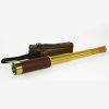
Yup got the spyglass yesterday, which in China terms is express. Nice little toy, have been standing in the street like a pirate, overly it's fun, 25x magnification, so you get a good zoom, quite dark and a lot of chromatic shift, and quite shaky so it takes practice, the focus is also 2/3rds redundant, as it is focused from 10 foot to 3 mile or something within the first 3rd. And the beam alignment is difficult into the eye you need to hold it off your eye an inch, so to make it easy and cut the surrounding light out I made an eye piece. Good laugh thoughzoom Spyglass and case 106 1 sq.jpg similar to this one
 
Last edited:

Goatboy

Full Member
Jan 31, 2005
14,956
18
Scotland
Arr! She's be a beauty there ye lubber Petro! I'm asure the scurvy dogs in the port 'round ye will be aworrying 'bout you standin' in the street with that 'un. Are ye gonna make a patch fer the t'other eye to be goin' with yer eye piece?
 

BCUK Shop

We have a a number of knives, T-Shirts and other items for sale.

SHOP HERE