We were blessed with another glorious day on Sunday. I'd planned to head out somewhere anyway, but the blue skies and good visibility really were a treat.
The date: Sunday 21st April 2024
The route: https://explore.osmaps.com/route/17...-1.655912&zoom=13.7840&style=Standard&type=2d
If you'd like to see my video from the walk rather than reading, it can be found here:
The walk:
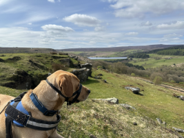
Starting on Mortimer Road just North West of the Strines and Dale Dyke reservoirs, I was immediately treated to a nice downhill stretch flanked on one side by woodland and the other by a field of sheep. The view right from where I parked up was lovely, as the hillside and trees turns into the glittering water of a Peak District reservoir.
My route took me slightly South East from where I parked and then I handrailed the Dales Dyke reservoir on the high ground up to the North East. It's all old agricultural land with old stone walls and the well renowned variety of gates and styles of the region. Cutting down hill further to the track around Dales Dyke, I was met with some signage giving a brief history of the area, including a memorial to those who died in the Great Sheffield Flood, which occurred in 1864 when the Dales Dyke dam broke upon first filling, and several hundred people lost their lives.
Crossing next to the weir on the North Eastern point of the reservoir, I was met with a steep incline with fairly large steps. This woke my legs up, rather rudely if I might say so. However, the incline initially was through more woodland and the breeze and shade was a welcome reprieve from the combination of hills and sunshine. This was the start of some rather tricky stiles, however. The Peak District is not easy with a large dog, when it comes to wall crossings. 31kg of Labrador ensured that my arms and back did not feel left out by all the excitement my legs were having.
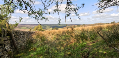
This was not to last. Breaking the treeline, I was met with the steepest part of the walk. I am not at my fittest and with 15kg(ish) on my back, this was quite the leg burner. The occasional glance over my shoulder did make this worth it, however, as the views behind me were wonderful. We stopped at the top to have a little breather, take on some water and enjoy the vista.

The next couple of miles were steady, but less severe incline as I headed South West in the general direction of the Hollow Meadows hamlet. The breeze up here was again most welcome.
Now we head North West. Through some very boggy fields and starting the main downhill portion of the walk, we narrowly avoided sinking up to the shoulders in sheep poo and mud and found ourselves on a slightly more forgiving-underfoot stretch. A little copse on the edge of the footpath ended up being a rather lovely spot to perch for some lunch.

Today's delicacy was a British military ration meal of Spicy Sausage and Potato Wedges (which was fine, but nothing to write home about) and a vanilla cake of the same origin (which was rather lovely!). Bushbox LF twig stove again made this a nice hot meal and allowed me to enjoy a cup of tea whilst enjoying the view.
The rest of the downhill stretch took me through the grounds of Sugworth Hall (I would like to win the Euromillions tonight so I can buy it) and past Boot's Folly, which was built in 1927 but looks kind of cool and castle-like. From there we had sheep and more ankle deep patches of boggy land where the water was making its way down the hill. Views of the two reservoirs and the dam made this a very pleasant place to be, regardless of the ground conditions.
Once I reached the bottom, it was yet again uphill for the rest of the walk today. Loads of vibrant spring colours around here. I encountered a bumblebee and plenty of butterflies, which also provided some nice inspiration for the upward climb.
Apart from a fly attempting to take up residence in my lungs on the way back up, this leg was fairly uneventful. Although my heart, lungs and legs may beg to differ on this account.
Overall the route was just over 8 miles - the OSMaps route had obviously been entered retroactively so a few corners were cut as they clicked around the route, but it didn't vary by a huge amount. Just under a mile in discrepancy, and that includes me wandering off path a little bit.
Alas, I did not find any wild garlic - this is proving quite elusive to me up here. There was loads in Devon, but I'm yet to find any decent spots this far North. I'm sure it's around somewhere. Absolutely stacks of Garlic Mustard and Dandelion though, so plenty enough to keep the forager happy for greens.
Can't wait to get back to the Peaks as I only really touched a small corner of it.
The date: Sunday 21st April 2024
The route: https://explore.osmaps.com/route/17...-1.655912&zoom=13.7840&style=Standard&type=2d
If you'd like to see my video from the walk rather than reading, it can be found here:
The walk:
Starting on Mortimer Road just North West of the Strines and Dale Dyke reservoirs, I was immediately treated to a nice downhill stretch flanked on one side by woodland and the other by a field of sheep. The view right from where I parked up was lovely, as the hillside and trees turns into the glittering water of a Peak District reservoir.
My route took me slightly South East from where I parked and then I handrailed the Dales Dyke reservoir on the high ground up to the North East. It's all old agricultural land with old stone walls and the well renowned variety of gates and styles of the region. Cutting down hill further to the track around Dales Dyke, I was met with some signage giving a brief history of the area, including a memorial to those who died in the Great Sheffield Flood, which occurred in 1864 when the Dales Dyke dam broke upon first filling, and several hundred people lost their lives.
Crossing next to the weir on the North Eastern point of the reservoir, I was met with a steep incline with fairly large steps. This woke my legs up, rather rudely if I might say so. However, the incline initially was through more woodland and the breeze and shade was a welcome reprieve from the combination of hills and sunshine. This was the start of some rather tricky stiles, however. The Peak District is not easy with a large dog, when it comes to wall crossings. 31kg of Labrador ensured that my arms and back did not feel left out by all the excitement my legs were having.
This was not to last. Breaking the treeline, I was met with the steepest part of the walk. I am not at my fittest and with 15kg(ish) on my back, this was quite the leg burner. The occasional glance over my shoulder did make this worth it, however, as the views behind me were wonderful. We stopped at the top to have a little breather, take on some water and enjoy the vista.

The next couple of miles were steady, but less severe incline as I headed South West in the general direction of the Hollow Meadows hamlet. The breeze up here was again most welcome.
Now we head North West. Through some very boggy fields and starting the main downhill portion of the walk, we narrowly avoided sinking up to the shoulders in sheep poo and mud and found ourselves on a slightly more forgiving-underfoot stretch. A little copse on the edge of the footpath ended up being a rather lovely spot to perch for some lunch.

Today's delicacy was a British military ration meal of Spicy Sausage and Potato Wedges (which was fine, but nothing to write home about) and a vanilla cake of the same origin (which was rather lovely!). Bushbox LF twig stove again made this a nice hot meal and allowed me to enjoy a cup of tea whilst enjoying the view.
The rest of the downhill stretch took me through the grounds of Sugworth Hall (I would like to win the Euromillions tonight so I can buy it) and past Boot's Folly, which was built in 1927 but looks kind of cool and castle-like. From there we had sheep and more ankle deep patches of boggy land where the water was making its way down the hill. Views of the two reservoirs and the dam made this a very pleasant place to be, regardless of the ground conditions.
Once I reached the bottom, it was yet again uphill for the rest of the walk today. Loads of vibrant spring colours around here. I encountered a bumblebee and plenty of butterflies, which also provided some nice inspiration for the upward climb.
Apart from a fly attempting to take up residence in my lungs on the way back up, this leg was fairly uneventful. Although my heart, lungs and legs may beg to differ on this account.
Overall the route was just over 8 miles - the OSMaps route had obviously been entered retroactively so a few corners were cut as they clicked around the route, but it didn't vary by a huge amount. Just under a mile in discrepancy, and that includes me wandering off path a little bit.
Alas, I did not find any wild garlic - this is proving quite elusive to me up here. There was loads in Devon, but I'm yet to find any decent spots this far North. I'm sure it's around somewhere. Absolutely stacks of Garlic Mustard and Dandelion though, so plenty enough to keep the forager happy for greens.
Can't wait to get back to the Peaks as I only really touched a small corner of it.
