Sennen on the mainland to the Isles of Scilly
Where it all began
This trip all started in July 2012 here
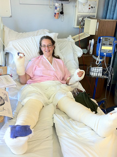 After the accident by Susannah Relf, on Flickr
As I lay in bed and looked to the future, I figured I was going to need something to motivate me to get back to full health. I needed a challenge. My boyfriend, Ian, and I had talked about the paddle from the mainland to the Scillies. Friends in the club had done it. But we had never really considered it for ourselves. I started to wonder if maybe this was the challenge I needed.
Not very long afterwards, our friend Chris from the kayak club died of cancer. He was looked after in St Julia's hospice and all of us in the kayak club felt the need to do something to mark his, and another kayaker who died in a road accident's, passing. The club did a 24 hour sponsored paddle in aid of the hospice. Ian and I promised we would kayak from the mainland to the Isles of Scilly for the same cause.
Training
​By the time I regained the ability to walk and started physiotherapy, I had lost all of my fitness and gained considerable weight. My training in 2013 had to start from square one. I took up swimming at the local leisure center. Initially 10 lengths 3 times per week - all breast-stroke. I gradually increased the number and style of lengths....8 breast-stroke, 2 front-crawl....16 breast-stroke, 4 front crawl...10 of each and so on. Surprisingly quickly, I was doing 60 lengths non-stop front crawl 3 times per week as fast as I could go (I got it down to 35 mins or less in the end!). 60 lengths = 1.5 km.
Ian also worked on his fitness running, surfing and swimming.
During the summer, we went out for as many paddles with the kayak club as possible. By the end of the summer, we managed a long open-water practice paddle, with friends Sam and Scott, from Mousehole to Mullion across Mounts Bay and then on around the Lizard to Cadgwith, a total of around 20 miles. This gave us confidence we were ready.
The next time a period of stable high pressure and fair weather was forecast to coincide with time off work for us both was in September 2013. We persuaded Ian's parents to come down and man a safety boat, got all our kit ready, told all our sponsors we were off...and got up in the morning to thick fog. Our route would take us across two busy shipping lanes. The big container ships travel at around five times the speed of us paddling, we couldn't afford to attempt the crossing with poor visibility and had to postpone.
It was a very difficult decision for us both. We thought it would mean training all winter in order to be ready next year...in the end, it meant training all winter and for a whole 'nother year before we got another chance. Ian got a job in Algeria in 2014, we got married and were sorting out a joint house as well as further operations and recoveries for me. All the time, the crossing was in mind and we kept training, but opportunity in 2014 never arose. However, the constant training meant by spring 2015 we were ready!
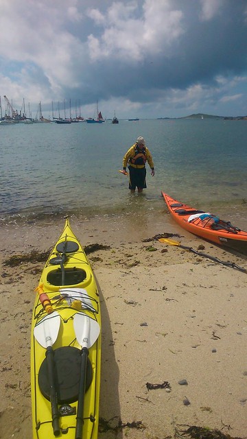
April/May/June we did several more practice paddles, including a trip from Newlyn to Sennen and an open-water across to Longships Lighthouse and back. By now, several other experienced club members wanted to come with us, so potentially we could have been a group of 5.
Route
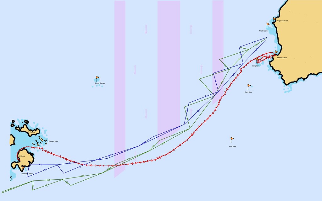 Plotted and actual routes by Susannah Relf, on Flickr
The blue is the route we calculated if we paddled on a constant bearing of 249 degrees from the Brisons and left at Spring High Water Devonport. The green is the same, but leaving at Spring High Water + 2 hours. The red is the actual track we followed, downloaded from our GPS. It includes an earlier trip to Longships Lighthouse and back.
The lanes with the pink arrows are the two shipping lanes in what is known as the shipping separation zone. Northbound ships all go in the eastern lane, southbound in the western lane.
To calculate the route, we obtained an Admiralty tidal streams atlas Falmouth to Padstow. We checked when the tides would be in our favour. Knowing we would be paddling at around 3 knots, we had already calculated it would take us around 8-9 hours to do the trip. Studying the atlas showed we had to leave between spring high water and spring high water+2.
Next, we got a marine chart covering our route. Using the tidal diamonds and tide information on the charts, we were able to plot the hourly routes. Each of the triangles on the blue and green routes above is composed of a line with one arrow, a line with two arrows and a line with three arrows.
The line with one arrow is the distance and direction if we paddled one hour on our bearing. The line with two arrows is the distance and direction the tide would travel during the same hour. The line with three arrows is the combination of us paddling and the tide and is the effective route.
Navigation
We talked to people who had done this trip in the past, as well as local fishermen, and gathered as much information as possible about actual tides compared with the forecast on the charts. From this, we had an inkling the tides past Longships Lighthouse might be slightly stronger than advertised. Having plotted the route, I had a good map in my head regarding what we would be likely to see at any point in our journey, and hence could have told if we had gone badly wrong. For example, a sighting of Carn Base would have been a bad sign!
We fitted compasses to our boats so we could paddle on the bearing (more or less, paddling on a bearing isn't a terribly accurate affair!)
We took GPS so we could verify our position if needed.
Interestingly, whilst talking to Chris Pease, who builds his own boats, we discovered that the Polynesians used to navigate by the angle of the dangle of their testicles, amongst other things. More about that here, for those interested https://www.ifa.hawaii.edu/friends/Technology_of_Oceania.pdf Being rather lacking in the testicular department, I was glad of our compasses!
Kit
The usual kayak clobber - boats, paddles, floatation aids, splash decks, spare splits.
Overnight gear - we arranged to stay with someone on the Scillies, so didn't need tents, but we did need to pack dry clothes, shoes, toiletries, money, phones.
Safety equipment - Flares, Epirb (personal locator beacon), GPS (x2), VHF radios (x2)
Food - loads of high energy snack food that could be eaten quickly on the go. Also a simple pack-lunch of sandwiches and boiled eggs.
Drink - 3 litres of water each.
Warm clothing
Travel Johns (I swear by them, Ian went for the go and wash it out afterwards technique).
Seasick tablets (just in case)
Sunblock
Sun hats
Safety precautions and tips and tricks
​Obviously, we had all the safety equipment mentioned above. Our clothing was all bright colours, as also our kayaks (bright orange and bright yellow). All fairly commonsense. Thinking about colours, I'm told that white is one of the least visible colours on the sea, as it blends in with foam and cloud reflections.
Ian had one of the rocket flares in his buoyancy aid pocket, ensuring it was close to hand in case we needed to make our presence felt to oncoming super-tankers.
We each stashed as many high energy snacks on our actual persons as possible to ensure that if conditions got too rough to open kayak hatches, we would still have food and drink at hand.
We ensured we paddled with all three of those who were on the potential team so we knew who was the slowest paddler (me!) and how fast we would, therefore, go (3 knots). This was on advice from another club member who failed the same crossing many years ago because they hadn't taken this precaution. They thought they would do the trip in 6 hours. Turns out, the slowest member wasn't that fast and they were still on the water after 8 hours...by which time the tide had swept them up well north of the Scillies. In the days before GPS, and being somewhat young and gung-ho, they had no idea this had happened and were cheerfully paddling out into the Atlantic 13 miles north of the Scillies when the storm hit. They were extremely fortunate to be picked up by a passing fishing trawler.
We called the coastguard and let them know when we left, and again when we arrived.
Family and friends all knew when and where we went.
We made sure to wear two-piece clothing rather than e.g. wetsuits. This made it easier when we needed a pee. We practised peeing enroute on some of our practice paddles. Some people find it really difficult to go when sat in a boat...it's better to find out in safe conditions than halfway to the Scillies on an 8 hour paddle!
We were careful not to stare at our compasses (liable to cause sea-sickness) but rather to check on the bearing every so often, and use other cues such as keeping the sun behind and a particular cloud in front for general paddling direction.
We had a potential safety boat, if Ian's parents were able to come down at the needed time (in the end, they couldn't, but supported our arrival back on the mainland instead!)
All of those on the potential team were experienced paddlers who we knew to be more than capable.
The Trip
By June, 2015 seemed to be passing us by, and we still hadn't had a weather window coincide with time off work. Ian decided to talk to his employers about our plans and see if they would support us by giving him time off at short notice. I had happily gone self-employed in 2014, so could simply let my clients know when I wouldn't be available. Only three weeks after Skybus agreed to help, a period of fair weather was forecast for 24th/25th June. Ian was off on 25th anyway and requested the 24th to give time to prepare. We let all our sponsors know it was looking imminent again...
By the evening of 23rd, the fair weather was looking shaky. The wind forecast had crept up to 12 knots against us on the Thursday. The swell was forecast 2 meters high and against us on the Wednesday. I let everyone know we wouldn't be going unless there was an improvement in the weather forecast, particularly as our safety boat was unable to make the dates. I swallowed hard and tried to accept the likely impending disappointment. Wednesday was a normal day at work, with the swell so large it was fairly breathtaking going down to our potential launch spots and watching it crashing in. I doubt we could have got off any of the beaches without capsize, let alone paddle against it for 9 hours.
However, by Wednesday evening the forecast for the following day had mellowed considerably! The swell was right down and dropping, the wind was light to moderate and only half against us (South rather than South Westerly). Suddenly, it looked feasible again. We fired off emails to let everyone know we were getting up with a view to leaving at 7am Thursday, rushed around to borrow the epirb from kayak friends, arranged accommodation on St Marys for Thursday night and packed all our kit. Neither of us slept very well, we were so excited to be leaving after all this time! Three years of preparation was finally coming to fruition.
Launch
Having seen the effects of even small swell at Priests Cove, Cape Cornwall and Boat Cove, we decided our safest option was to launch from Sennen Cove and paddle due west for an hour to meet our plotted route. Friends Clare and Nicky from the kayak club surprised and encouraged us by coming down to see us off. Here is Nicky's video of the departure, Clare offered to give us a push off the shore:
[video=youtube_share;kGNlgFfdZqE]http://youtu.be/kGNlgFfdZqE[/video]
We paddled 55 minutes, then 5 minutes rest every hour. I kept an eye on time, Ian had the GPS for reference, we both knew what we ought to be able to see each hour. That first hour was quite magical as there were thousands of common jellyfish in the water under our boats. It felt like we were scooping through them with our paddles, or that they were stars in a watery sky.
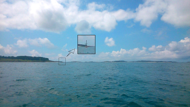
It was a strange mixture of achievement and apprehension to be on the water at last, paddling out to sea, after three years of training. After one hour, we were the furthest away from land we'd been before. Here a photo looking back at the mainland. We were still fairly close to Longships Lighthouse, but kept it to our South as we went by. Unfortunately, a water droplet obscures the lighthouse, but you can make out the dark line of the mainland.
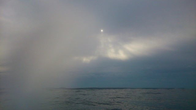 Looking back at the mainland by Susannah Relf, on Flickr
It was going to be some time yet before we would be able to see the islands. Although you can see them from the top of the mainland cliffs, at sea level they are not visible until you are nearly half way there! By the end of the second hour, we were the closest we were going to get to Wolf Rock lighthouse. You can just about make it out in the photograph.
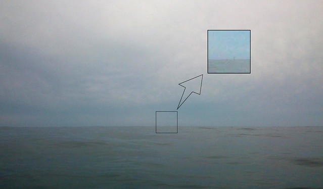 Wolf Rock Lighthouse by Susannah Relf, on Flickr
The next major route mark was the shipping separation zones, first the north-bound lane. Although there is no physical demarkation, there are so many ships, the lanes are pretty obvious. Here, our first cargo ship
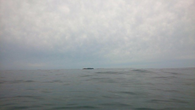 First shipping separation zone by Susannah Relf, on Flickr
At three hours, we had done 10 miles and were only 15 miles away from our target. But we still couldn't see them! Only ten minutes after we set off again, Ian and I started to see something each time we crested a wave. By four hours, we were certain it was land and we were starting to feel like we were probably going to make it. It still wasn't big enough to show on my camera. Sight of land, combined with the continued fantastic smooth sea conditions and very light winds meant we started to feel confident.
As we came up to the south bound shipping lane, we had the hairiest moment of our trip. We saw a cargo ship and figured if it kept on and we slowed our paddle, we should be alright. But then it started to turn towards us!!!! We weren't sure which way to go. A few seconds of adrenaline, then we realised it had stopped its turn and we waited as it went by. It had obviously seen us, and finished its turn once it was past. Had it got any closer, Ian would have fired his flare to warn them of our presence!A useful fact we figured out from this experience was that we were slightly south of the shipping separation zone. Our route should have been close to the southern end, but not off it!! So we checked the GPS and adjusted our bearing to a more westerly heading.
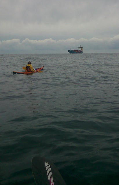 Second shipping separation zone by Susannah Relf, on Flickr
From about halfway onwards, we kept seeing sunfish basking near the surface. These are bizarre creatures that are shaped like dinner plates, but can grow much larger. Wikipedia describes them as being like a fish head with a tail. At any rate, they are very interesting to see and we were delighted when one jumped a foot clear of the water in front of us! I'm not sure how they do it, but they certainly can jump. I didn't get a good photo, but you can see the fin of one here.
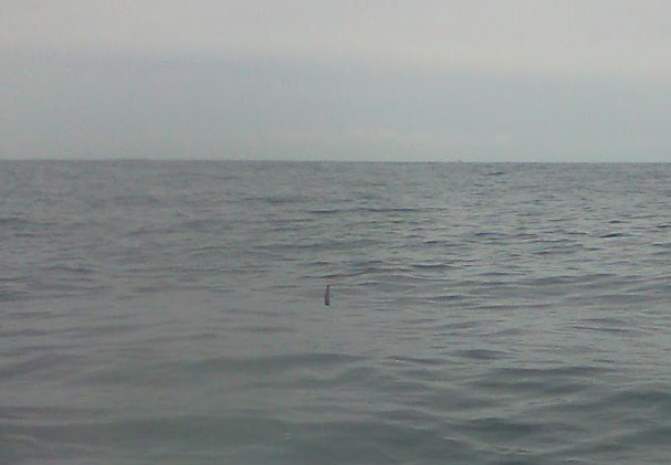 Sunfish by Susannah Relf, on Flickr
At the fifth break, we could clearly see the different islands and made up our minds to head in through the Eastern Isles rather than through St Mary's Sound. We started to rely less on the compasses and more on what we could see. The islands were still too small to show much on photo, though!
 Getting closer by Susannah Relf, on Flickr
By the sixth hour, we were both starting to feel tired. Land was very welcome, but it was taking a long time to come closer and my morale was starting to drop as my blisters were hurting. We never entertained any possibility of stopping - it was certain we were going to make it now - but I needed to do something to cheer myself on. So I started to sing.
 We can see the scillies by Susannah Relf, on Flickr
Tired and tetchy, Ian didn't like my singing as he was trying to concentrate on the GPS. Being tired, he was reading it incorrectly in some way and had got the impression we were getting further from our target rather than closer. He was worried the tide was too strong for us and had turned against us, and so he paddled silently off ahead to get away from my singing.
He is in this picture, honest! I had to call him on the VHF to tell him it was break time.
 Ian way off in front by Susannah Relf, on Flickr
The break did us good. Ian sorted out his GPS thing and realised we were doing fine. We made it up and paddled on around St Mary's to land at Porth Loo, where we had arranged accommodation. It took us another hour and a quarter to get around the island, so the trip took a total of 8 1/4 hours, well within our estimation.
Ian asked me to lead the landing and I had an immense feeling of pride and emotion as we complete this journey. It had taken us 3 years, several operations, hours of training, support from hundreds of people. We'd gotten married. My grandma died of a brain tumour and was looked after in St Julia's. So much had happened, and here I was about to land. I cried.
 Arriving at Porth Loo by Susannah Relf, on Flickr
8 hours in a boat meant our legs didn't work properly. Ian is standing like that because he couldn't walk forwards for a few minutes. He could walk backwards, but not forwards! It took about 10 - 15 minutes for my legs to come back. Also, my main moment of sea-sickness was still to come. Reading the menu in the restaurant that night, it felt like the whole restaurant was rocking up and down and I started to feel queasy focussing on the menu!!
The following day, we arranged passage back to the mainland on the Scillonian ferry. Here we are with our boats just after we made land
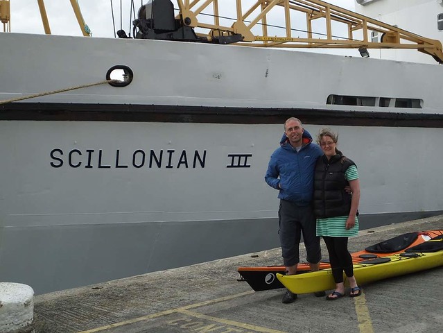 Returned by Susannah Relf, on Flickr
Hopefully, if you've got this far down the post, you've enjoyed our story. So far, we've raised over £1000 for St Julia's hospice, who not only looked after our friend Chris, but also my Grandma and another friends wife during the years we were training. If you, like us, feel the work of hospices is a vital part of patient care and are able to spare a few bucks, please consider sponsoring us
http://justgiving.com/Susannah-Relf
I should add that Skybus, Ian's employers, kindly gave us free travel back as well as carrying our boats for us. We have donated what we would have spent on travel to St Julias.
Where it all began
This trip all started in July 2012 here
After the accident by Susannah Relf, on FlickrAs I lay in bed and looked to the future, I figured I was going to need something to motivate me to get back to full health. I needed a challenge. My boyfriend, Ian, and I had talked about the paddle from the mainland to the Scillies. Friends in the club had done it. But we had never really considered it for ourselves. I started to wonder if maybe this was the challenge I needed.
Not very long afterwards, our friend Chris from the kayak club died of cancer. He was looked after in St Julia's hospice and all of us in the kayak club felt the need to do something to mark his, and another kayaker who died in a road accident's, passing. The club did a 24 hour sponsored paddle in aid of the hospice. Ian and I promised we would kayak from the mainland to the Isles of Scilly for the same cause.
Training
​By the time I regained the ability to walk and started physiotherapy, I had lost all of my fitness and gained considerable weight. My training in 2013 had to start from square one. I took up swimming at the local leisure center. Initially 10 lengths 3 times per week - all breast-stroke. I gradually increased the number and style of lengths....8 breast-stroke, 2 front-crawl....16 breast-stroke, 4 front crawl...10 of each and so on. Surprisingly quickly, I was doing 60 lengths non-stop front crawl 3 times per week as fast as I could go (I got it down to 35 mins or less in the end!). 60 lengths = 1.5 km.
Ian also worked on his fitness running, surfing and swimming.
During the summer, we went out for as many paddles with the kayak club as possible. By the end of the summer, we managed a long open-water practice paddle, with friends Sam and Scott, from Mousehole to Mullion across Mounts Bay and then on around the Lizard to Cadgwith, a total of around 20 miles. This gave us confidence we were ready.
The next time a period of stable high pressure and fair weather was forecast to coincide with time off work for us both was in September 2013. We persuaded Ian's parents to come down and man a safety boat, got all our kit ready, told all our sponsors we were off...and got up in the morning to thick fog. Our route would take us across two busy shipping lanes. The big container ships travel at around five times the speed of us paddling, we couldn't afford to attempt the crossing with poor visibility and had to postpone.
It was a very difficult decision for us both. We thought it would mean training all winter in order to be ready next year...in the end, it meant training all winter and for a whole 'nother year before we got another chance. Ian got a job in Algeria in 2014, we got married and were sorting out a joint house as well as further operations and recoveries for me. All the time, the crossing was in mind and we kept training, but opportunity in 2014 never arose. However, the constant training meant by spring 2015 we were ready!
April/May/June we did several more practice paddles, including a trip from Newlyn to Sennen and an open-water across to Longships Lighthouse and back. By now, several other experienced club members wanted to come with us, so potentially we could have been a group of 5.
Route
Plotted and actual routes by Susannah Relf, on FlickrThe blue is the route we calculated if we paddled on a constant bearing of 249 degrees from the Brisons and left at Spring High Water Devonport. The green is the same, but leaving at Spring High Water + 2 hours. The red is the actual track we followed, downloaded from our GPS. It includes an earlier trip to Longships Lighthouse and back.
The lanes with the pink arrows are the two shipping lanes in what is known as the shipping separation zone. Northbound ships all go in the eastern lane, southbound in the western lane.
To calculate the route, we obtained an Admiralty tidal streams atlas Falmouth to Padstow. We checked when the tides would be in our favour. Knowing we would be paddling at around 3 knots, we had already calculated it would take us around 8-9 hours to do the trip. Studying the atlas showed we had to leave between spring high water and spring high water+2.
Next, we got a marine chart covering our route. Using the tidal diamonds and tide information on the charts, we were able to plot the hourly routes. Each of the triangles on the blue and green routes above is composed of a line with one arrow, a line with two arrows and a line with three arrows.
The line with one arrow is the distance and direction if we paddled one hour on our bearing. The line with two arrows is the distance and direction the tide would travel during the same hour. The line with three arrows is the combination of us paddling and the tide and is the effective route.
Navigation
We talked to people who had done this trip in the past, as well as local fishermen, and gathered as much information as possible about actual tides compared with the forecast on the charts. From this, we had an inkling the tides past Longships Lighthouse might be slightly stronger than advertised. Having plotted the route, I had a good map in my head regarding what we would be likely to see at any point in our journey, and hence could have told if we had gone badly wrong. For example, a sighting of Carn Base would have been a bad sign!
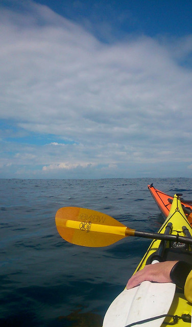
We fitted compasses to our boats so we could paddle on the bearing (more or less, paddling on a bearing isn't a terribly accurate affair!)
We took GPS so we could verify our position if needed.
Interestingly, whilst talking to Chris Pease, who builds his own boats, we discovered that the Polynesians used to navigate by the angle of the dangle of their testicles, amongst other things. More about that here, for those interested https://www.ifa.hawaii.edu/friends/Technology_of_Oceania.pdf Being rather lacking in the testicular department, I was glad of our compasses!
Kit
The usual kayak clobber - boats, paddles, floatation aids, splash decks, spare splits.
Overnight gear - we arranged to stay with someone on the Scillies, so didn't need tents, but we did need to pack dry clothes, shoes, toiletries, money, phones.
Safety equipment - Flares, Epirb (personal locator beacon), GPS (x2), VHF radios (x2)
Food - loads of high energy snack food that could be eaten quickly on the go. Also a simple pack-lunch of sandwiches and boiled eggs.
Drink - 3 litres of water each.
Warm clothing
Travel Johns (I swear by them, Ian went for the go and wash it out afterwards technique).
Seasick tablets (just in case)
Sunblock
Sun hats
Safety precautions and tips and tricks
​Obviously, we had all the safety equipment mentioned above. Our clothing was all bright colours, as also our kayaks (bright orange and bright yellow). All fairly commonsense. Thinking about colours, I'm told that white is one of the least visible colours on the sea, as it blends in with foam and cloud reflections.
Ian had one of the rocket flares in his buoyancy aid pocket, ensuring it was close to hand in case we needed to make our presence felt to oncoming super-tankers.
We each stashed as many high energy snacks on our actual persons as possible to ensure that if conditions got too rough to open kayak hatches, we would still have food and drink at hand.
We ensured we paddled with all three of those who were on the potential team so we knew who was the slowest paddler (me!) and how fast we would, therefore, go (3 knots). This was on advice from another club member who failed the same crossing many years ago because they hadn't taken this precaution. They thought they would do the trip in 6 hours. Turns out, the slowest member wasn't that fast and they were still on the water after 8 hours...by which time the tide had swept them up well north of the Scillies. In the days before GPS, and being somewhat young and gung-ho, they had no idea this had happened and were cheerfully paddling out into the Atlantic 13 miles north of the Scillies when the storm hit. They were extremely fortunate to be picked up by a passing fishing trawler.
We called the coastguard and let them know when we left, and again when we arrived.
Family and friends all knew when and where we went.
We made sure to wear two-piece clothing rather than e.g. wetsuits. This made it easier when we needed a pee. We practised peeing enroute on some of our practice paddles. Some people find it really difficult to go when sat in a boat...it's better to find out in safe conditions than halfway to the Scillies on an 8 hour paddle!
We were careful not to stare at our compasses (liable to cause sea-sickness) but rather to check on the bearing every so often, and use other cues such as keeping the sun behind and a particular cloud in front for general paddling direction.
We had a potential safety boat, if Ian's parents were able to come down at the needed time (in the end, they couldn't, but supported our arrival back on the mainland instead!)
All of those on the potential team were experienced paddlers who we knew to be more than capable.
The Trip
By June, 2015 seemed to be passing us by, and we still hadn't had a weather window coincide with time off work. Ian decided to talk to his employers about our plans and see if they would support us by giving him time off at short notice. I had happily gone self-employed in 2014, so could simply let my clients know when I wouldn't be available. Only three weeks after Skybus agreed to help, a period of fair weather was forecast for 24th/25th June. Ian was off on 25th anyway and requested the 24th to give time to prepare. We let all our sponsors know it was looking imminent again...
By the evening of 23rd, the fair weather was looking shaky. The wind forecast had crept up to 12 knots against us on the Thursday. The swell was forecast 2 meters high and against us on the Wednesday. I let everyone know we wouldn't be going unless there was an improvement in the weather forecast, particularly as our safety boat was unable to make the dates. I swallowed hard and tried to accept the likely impending disappointment. Wednesday was a normal day at work, with the swell so large it was fairly breathtaking going down to our potential launch spots and watching it crashing in. I doubt we could have got off any of the beaches without capsize, let alone paddle against it for 9 hours.
However, by Wednesday evening the forecast for the following day had mellowed considerably! The swell was right down and dropping, the wind was light to moderate and only half against us (South rather than South Westerly). Suddenly, it looked feasible again. We fired off emails to let everyone know we were getting up with a view to leaving at 7am Thursday, rushed around to borrow the epirb from kayak friends, arranged accommodation on St Marys for Thursday night and packed all our kit. Neither of us slept very well, we were so excited to be leaving after all this time! Three years of preparation was finally coming to fruition.
Launch
Having seen the effects of even small swell at Priests Cove, Cape Cornwall and Boat Cove, we decided our safest option was to launch from Sennen Cove and paddle due west for an hour to meet our plotted route. Friends Clare and Nicky from the kayak club surprised and encouraged us by coming down to see us off. Here is Nicky's video of the departure, Clare offered to give us a push off the shore:
[video=youtube_share;kGNlgFfdZqE]http://youtu.be/kGNlgFfdZqE[/video]
We paddled 55 minutes, then 5 minutes rest every hour. I kept an eye on time, Ian had the GPS for reference, we both knew what we ought to be able to see each hour. That first hour was quite magical as there were thousands of common jellyfish in the water under our boats. It felt like we were scooping through them with our paddles, or that they were stars in a watery sky.
It was a strange mixture of achievement and apprehension to be on the water at last, paddling out to sea, after three years of training. After one hour, we were the furthest away from land we'd been before. Here a photo looking back at the mainland. We were still fairly close to Longships Lighthouse, but kept it to our South as we went by. Unfortunately, a water droplet obscures the lighthouse, but you can make out the dark line of the mainland.
Looking back at the mainland by Susannah Relf, on FlickrIt was going to be some time yet before we would be able to see the islands. Although you can see them from the top of the mainland cliffs, at sea level they are not visible until you are nearly half way there! By the end of the second hour, we were the closest we were going to get to Wolf Rock lighthouse. You can just about make it out in the photograph.
Wolf Rock Lighthouse by Susannah Relf, on FlickrThe next major route mark was the shipping separation zones, first the north-bound lane. Although there is no physical demarkation, there are so many ships, the lanes are pretty obvious. Here, our first cargo ship
First shipping separation zone by Susannah Relf, on FlickrAt three hours, we had done 10 miles and were only 15 miles away from our target. But we still couldn't see them! Only ten minutes after we set off again, Ian and I started to see something each time we crested a wave. By four hours, we were certain it was land and we were starting to feel like we were probably going to make it. It still wasn't big enough to show on my camera. Sight of land, combined with the continued fantastic smooth sea conditions and very light winds meant we started to feel confident.
As we came up to the south bound shipping lane, we had the hairiest moment of our trip. We saw a cargo ship and figured if it kept on and we slowed our paddle, we should be alright. But then it started to turn towards us!!!! We weren't sure which way to go. A few seconds of adrenaline, then we realised it had stopped its turn and we waited as it went by. It had obviously seen us, and finished its turn once it was past. Had it got any closer, Ian would have fired his flare to warn them of our presence!A useful fact we figured out from this experience was that we were slightly south of the shipping separation zone. Our route should have been close to the southern end, but not off it!! So we checked the GPS and adjusted our bearing to a more westerly heading.
Second shipping separation zone by Susannah Relf, on FlickrFrom about halfway onwards, we kept seeing sunfish basking near the surface. These are bizarre creatures that are shaped like dinner plates, but can grow much larger. Wikipedia describes them as being like a fish head with a tail. At any rate, they are very interesting to see and we were delighted when one jumped a foot clear of the water in front of us! I'm not sure how they do it, but they certainly can jump. I didn't get a good photo, but you can see the fin of one here.
Sunfish by Susannah Relf, on FlickrAt the fifth break, we could clearly see the different islands and made up our minds to head in through the Eastern Isles rather than through St Mary's Sound. We started to rely less on the compasses and more on what we could see. The islands were still too small to show much on photo, though!
Getting closer by Susannah Relf, on FlickrBy the sixth hour, we were both starting to feel tired. Land was very welcome, but it was taking a long time to come closer and my morale was starting to drop as my blisters were hurting. We never entertained any possibility of stopping - it was certain we were going to make it now - but I needed to do something to cheer myself on. So I started to sing.
We can see the scillies by Susannah Relf, on FlickrTired and tetchy, Ian didn't like my singing as he was trying to concentrate on the GPS. Being tired, he was reading it incorrectly in some way and had got the impression we were getting further from our target rather than closer. He was worried the tide was too strong for us and had turned against us, and so he paddled silently off ahead to get away from my singing.
He is in this picture, honest! I had to call him on the VHF to tell him it was break time.
Ian way off in front by Susannah Relf, on FlickrThe break did us good. Ian sorted out his GPS thing and realised we were doing fine. We made it up and paddled on around St Mary's to land at Porth Loo, where we had arranged accommodation. It took us another hour and a quarter to get around the island, so the trip took a total of 8 1/4 hours, well within our estimation.
Ian asked me to lead the landing and I had an immense feeling of pride and emotion as we complete this journey. It had taken us 3 years, several operations, hours of training, support from hundreds of people. We'd gotten married. My grandma died of a brain tumour and was looked after in St Julia's. So much had happened, and here I was about to land. I cried.
Arriving at Porth Loo by Susannah Relf, on Flickr8 hours in a boat meant our legs didn't work properly. Ian is standing like that because he couldn't walk forwards for a few minutes. He could walk backwards, but not forwards! It took about 10 - 15 minutes for my legs to come back. Also, my main moment of sea-sickness was still to come. Reading the menu in the restaurant that night, it felt like the whole restaurant was rocking up and down and I started to feel queasy focussing on the menu!!
The following day, we arranged passage back to the mainland on the Scillonian ferry. Here we are with our boats just after we made land
Returned by Susannah Relf, on FlickrHopefully, if you've got this far down the post, you've enjoyed our story. So far, we've raised over £1000 for St Julia's hospice, who not only looked after our friend Chris, but also my Grandma and another friends wife during the years we were training. If you, like us, feel the work of hospices is a vital part of patient care and are able to spare a few bucks, please consider sponsoring us
http://justgiving.com/Susannah-Relf
I should add that Skybus, Ian's employers, kindly gave us free travel back as well as carrying our boats for us. We have donated what we would have spent on travel to St Julias.
 Major kudos for both the planning and successful outcome
 ")
")