The Yosemite High Sierra Loop

  • Hey Guest, Early bird pricing on the Summer Moot (29th July - 10th August) available until April 6th, we'd love you to come. PLEASE CLICK HERE to early bird price and get more information.
Hi Everyone!

I added another link to the first post in this thread.


bcfrm_Brook_Trout.jpg


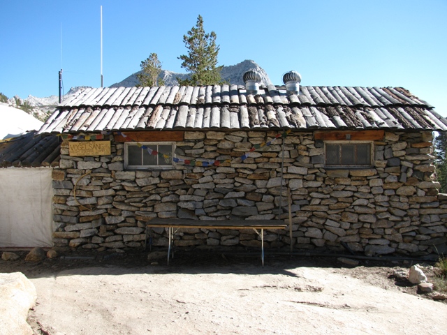
The High Sierra Loop - Glen Aulin to May Lake
Glen Aulin to May Lake
Starting Elevation: 7800 ft. (2378 m)
Ending Elevation: 9270 ft. (2825 m)
Approximate Mileage: 8.5 miles (13.7 km)
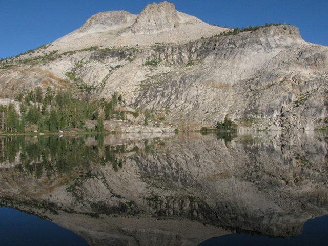
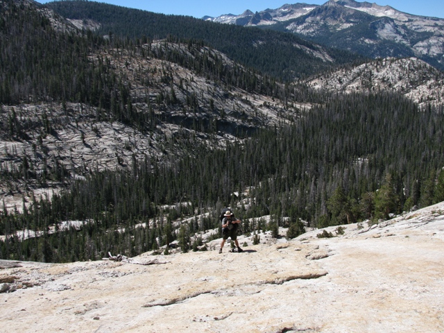
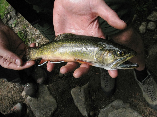
We climb from Glen Aulin through lodgepole pine forest and ascend an imposing granite ridge. We manage to catch some food for dinner along the way and enjoy the colors of the sunset displayed on the granite peaks.


- Woodsorrel
 

Qwerty

Settler
Mar 20, 2011
624
13
Ireland
www.instagram.com
"We were hot, tired, and the “Check Engine” light had been on for the last two miles."

What a great sentence :lmao:

Can I ask, what kind of cost is involved in having a guided tour like this rather than a DIY trip?
 

Chainsaw

Native
Jul 23, 2007
1,377
144
56
Central Scotland
Just got back on Monday :) 
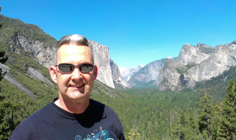
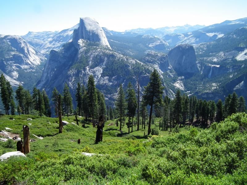
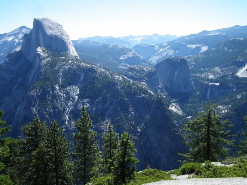
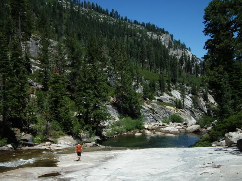
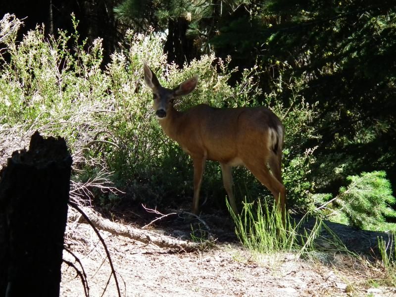
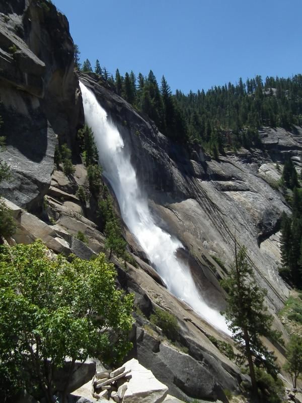
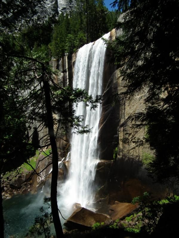
Amazing place. We have some pretty good scenery up here and I was prepared to be 'underawed' but it was truly an epic and beautiful place. Definitely bucket list fodder. My only complaint is that there were too many people there :D (it was the 4th July weekend) Had family with so only had one hike and one horse trek. We did Glacier point down to the valley, was about 9 miles or so. Very hot, too hot for us Scottish people, took about 7 litres of water and myself and Little Chainsaw pretty much guzzled the lot. Next time will be off season and to somewhere off the beaten track. Some pics below;

Cheesey grin from yours truly as we came out of the tunnel to the viewpoint

IMAG0274_zps6aa879f1.jpg


Heading down from glacier point, views were staggering

DSCF3112_zpscb53d0a3.jpg


This is why they call it the panorama trail! It's like one of those computer generated landscapes but in real life!

DSCF3096_zps0279dfa9.jpg


Stopped at the illouette falls (sp?) for lunch and a cool off (little chainsaw in background, 6ft1!)

DSCF3138_zps61d017ff.jpg


Some wildlife

DSCF3128_zpsd4c9ebe5.jpg


It was a trifle dusty :D

IMG_2238_zps4c4ff353.jpg


Great hike but the last stages were marred by busloads of people, still can't complain. Hopefully this should link ok to my strava.

Cheers,

Alan
 

Alamo

Member
May 4, 2009
30
0
Lancashire
If anyone gets even a tiny chance to go to Yosemite. Then grab it with both hands and everything you have got. It's simply not possable to discribe how amazing it is.


Couldn't agree more.....a truly awesome place like no other to visit.

The wife and I have visited Yosemite three times in the last 10 years and will no doubt be doing the same again next year when we visit my brother-in-law again in San Jose.

We were last there two years ago, which included a week at Lake Tahoe...... another great place as long as you don't have a weakness for gambling.

Fantastic photos Woodsorrel - thanks for bringing back the memories.

Alan
 
Last edited:
"We were hot, tired, and the “Check Engine” light had been on for the last two miles."

What a great sentence :lmao:

Can I ask, what kind of cost is involved in having a guided tour like this rather than a DIY trip?

Hi Qwerty! Here is a link to the official information with all of the options, along with prices (http://www.yosemitepark.com/high-sierra-camp-rates.aspx).

There are often "specials" that are listed on this page (http://www.yosemitepark.com/high-sierra-camps.aspx).


To summarize for 2014:

Meals & Lodging (includes lodging, dinner, breakfast) per day: Adult:$161 Child: $102 (Cheaper at Vogelsang)
7-Day Guided Hike (includes lodging, meals, and guide) total: Adults $1442.25 Child: $1044.25

So with the 7-day guided trip you pay $45 more each day for 1 extra meal (bag lunch), the guide, full-loop reservations, and to be part of a jovial band.

I believe that the adjacent backpackers campgrounds are significantly less expensive. Several less expensive options, including pack trips, are listed on the linked-page.


- Woodsorrel
 
Chainsaw, those are amazing pictures! You visited the most famous part of Yosemite, Yosemite Valley. Your picture at Tunnel View is iconic - El Capitan over your left shoulder with Half Dome in the background.

The Panorama Trail is one of my favorite hikes in Yosemite! It sure beats hiking up to Glacier Point. :)

I love your picture from the lookout. You capture Half Dome and Nevada Falls. Did you get a chance to see Nevada and Vernal falls on your hike down to the Valley?

- Woodsorrel
 

Chainsaw

Native
Jul 23, 2007
1,377
144
56
Central Scotland
Yep we took a wee detour up to see Nevada falls, the descent from there on the north bank was horrible, steep and busy.

DSCF3156_zps325d3a70.jpg


We then got down to Vernal falls and it was a zoo, extremely busy from there all the way down to the valley floor.

DSCF3170_zps8e34a093.jpg


Maybe bleating on about the negatives too much, wouldn't have missed it for the world, amazing hike although would have been perfect earlier in the season.

I actually doubt I could hike up the panorama trail. The hike up from Illouette was bad enough, the heat just killed me, I actually had swollen hands from it (don't know why that happened) but a dip in the cool glacial water soon had them under control.
 
Last edited:
Yep we took a wee detour up to see Nevada falls, the descent from there on the north bank was horrible, steep and busy.

DSCF3156_zps325d3a70.jpg


We then got down to Vernal falls and it was a zoo, extremely busy from there all the way down to the valley floor.

DSCF3170_zps8e34a093.jpg


Maybe bleating on about the negatives too much, wouldn't have missed it for the world, amazing hike although would have been perfect earlier in the season.

I actually doubt I could hike up the panorama trail. The hike up from Illouette was bad enough, the heat just killed me, I actually had swollen hands from it (don't know why that happened) but a dip in the cool glacial water soon had them under control.

Chainsaw, I have hiked the Mist Trail past those falls half a dozen times and I don't have any pictures as nice as yours! Amazing!

I understand your complaint about the tourists. The Mist Trail is one of the most popular in Yosemite, for the reasons you discovered. The scenery is astounding! As I recall, you visited on a holiday weekend. That just compounds the problem.

Most of the casual hikers disappear after Vernal Falls. Between Vernal and Nevada Falls lies a serious calf-cramping climb. Despite the tourists, the natural beauty is so striking that I bring all my friends who visit to hike this trail. I think I mentioned already on the forum that, when I hiked it with business associates from Siberia, they were laughing at the public restrooms every 3-4 miles along the trail. :) Just the same, they talked about Yosemite for weeks after the trip.

I chose to describe my trip on the High Sierra Loop because it gives a taste of the "wild" Yosemite. Relatively few people visit the high country. It takes a lot of driving and/or hiking from the Valley and their are limited "conveniences" for tourists.

- Woodsorrel
 
... The hike up from Illouette was bad enough, the heat just killed me, I actually had swollen hands from it (don't know why that happened) but a dip in the cool glacial water soon had them under control.

Chainsaw, swollen hands are quite common for long-distance hikers. The most common reason is blood pooling in your hands. It is usually not a big deal and should resolve itself after you stop hiking.

This is a physiological response to hiking, but there can also be several other factors you can control. If your shoulder straps are too tight, it can reduce the flow of venous blood returning to your heart. So, the first thing to try is to loosen your shoulder straps and sternum strap. A second thing to try is lightening your load. I find this solution to be unpopular with spouses, girlfriends/boyfriends, and hiking buddies. :)

In rare cases, the swelling can be caused by salt depletion during the hike combined with the large intake of water. Essentially, it is the early stages of hyponatraemia. But, if you are feeling well overall, it is far more likely to be the result of blood pooling in your hands.

DISCLAIMER: I am not a medical professional, just a hiker.


- Woodsorrel
 

Chainsaw

Native
Jul 23, 2007
1,377
144
56
Central Scotland
Good info thanks woodsorrel. I wasn't over loaded by any means but it wasn't my rucksack so not set up for me and hadn't used it before so could be a factor. A lot of water and minimal salt may have been an issue but suspect I wasn't out for long enough for that to set in so sounds just like blood pooling/straps.

When I go back to Yosemite, I'll certainly look at the High Country rather than the valley but as a first time visitor, you kinda have to hit the valley. Back out to CA in 3 weeks but it's just work again, not much chance of any outdoorsy stuff.
 
Hi Everyone!

I added another link to the first post in this thread.


bcfrm_Hoffman.jpg


The High Sierra Loop - May Lake to Sunrise Camp
May Lake to Sunrise Camp
Starting Elevation: 9270 ft. (2825 m)
Ending Elevation: 9400 ft. (2865 m)
Approximate Mileage: 8.25 (13 km)
We descend from May Lake to Tenaya Lake and then climb the steep switchbacks to Clouds Rest junction. We hike through ancient junipers and swim in crystal clear lakes on our way to our camp overlooking the beautiful Long Meadow.


- Woodsorrel
 
Hi Everyone!

Sorry for the long delay. Life intervened. I am completing these posts with links for people who might be interested in taking this trip one day.


bcfrm_Jayne.jpg


The High Sierra Loop – Sunrise Camp to Merced Lake
Sunrise Camp to Merced Lake
Starting Elevation: 9400 ft. (2865 m)
Ending Elevation: 7150 ft. (2179 m)
Approximate Mileage: 9.5 miles (15.5 km)
The group bushwhacks in the spirit of the first explorers of Yosemite's high country. We cross Long Meadow and descend a rock formation named for a famous actress' distinct anatomy. Again off trail, we visit a hidden waterfall and fish for trout. Finally we ascend a granite trail beside the Merced River to arrive at our camp for days 4 & 5.


- Woodsorrel
 
Hi Everyone!

I added the final pictures/links to this post for people who might want to do a trip similar to this one.


bcfrm_vogelsang.jpg


The High Sierra Loop – Merced Lake to Vogelsang
Merced Lake to Vogelsang via Fletcher Creek
Starting Elevation: 7150 ft. (2179 m)
Ending Elevation: 10100 ft. (3078 m)
Approximate Mileage: 7.8 miles (12.5 km)
This is the last part of the series. We climb into alpine terrain, keeping cool by soaking in high mountain streams. After traversing a high mountain meadow, we arrive at Vogelsang camp (10,100'). I get a fly fishing lesson and land my first fish! It is a humongous gigantic enormous (NOT!) brook trout!

At this point, all portions of the hike have links (in blue text) on this thread for people who want to plan a similar trip. It was an amazing experience that I encourage everyone to try. For those hesitant to backpack, have problems carrying weight, or do not want to travel from the UK with a multi-night backpack, the High Sierra Loop gives you a true backcountry experience with the advantage of a warm place to sleep and congenial human company.

If you go on a trip in the Yosemite High Country, please feel free to share your experiences and pictures on this thread.

Regards!

- Woodsorrel
 

BCUK Shop

We have a a number of knives, T-Shirts and other items for sale.

SHOP HERE