Cartography Hobby: 'Omniteras - Rainfall Isle'

THOaken

Native
Jan 21, 2013
1,299
1
30
England(Scottish Native)
Some of you may know that I'm very interested and passionate about natural history, geography and cartography. I've always been interested in maps, really, but I've found myself being ever more drawn to them. I have many maps of Scotland and I collect leaflets from places I've travelled. Now, I don't consider myself a designer by any means, that title falls to a relative of mine, but I think I know enough about geography and have studied maps enough to attempt my own digital rendering of a fictional world. Most fictional geography is used for fantasy fiction, but I don't write fantasy fiction and, truth be told, don't read very much of it. I just enjoy designing maps as a hobby.

A couple of weeks ago I began to draw out a projection for a small isle, but then I decided to carry it over to digital design on the computer. I've been working on this rendering for maybe two or three days, and I'm trying to make it as detailed as possible. I'm extremely proud of what I've made and I'm shocked because I didn't know I could produce such a thing.

I proudly present to you a small preview of Rainfall Isle, the Lonely Archipelago, from my world of Omniteras, my answer to a close relative's own work:

Teaser.png


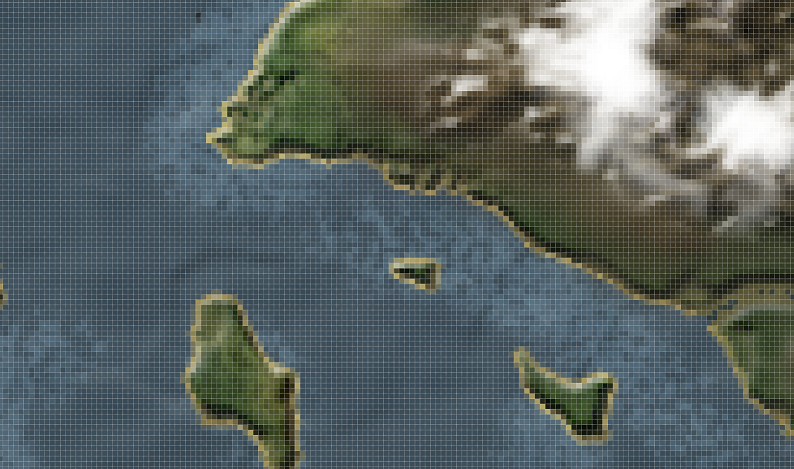
For those not familiar with Photoshop and map creation of this kind, no map generation software was used. This is all my work utilising various brushes and manipulating photos and effects.

I will be uploading a video of the finished map as this is something very dear to me now and I've spent many hours working on it.

Taylor.
 

Harvestman

Bushcrafter through and through
May 11, 2007
8,656
26
55
Pontypool, Wales, Uk
Now I find that really interesting. I love maps, and love creating them. I my teens I created a huge map that covered an entire wall of my bedroom, pencil drawn on a4 sheets, that I just expanded over time. I still have the sheets somewhere.

I look forward to your finished work.
 

Harvestman

Bushcrafter through and through
May 11, 2007
8,656
26
55
Pontypool, Wales, Uk
While I think of it, one of my favourite ideas that I will almost certainly never get around to doing is to take Wales, and turn it into an island, just to see what the east coast would look like, as simply cutting along the line of the boundary isn't enough. You would get new cliffs, beaches, estuaries, and probably small coastal islands too.

I'd love a bit of software that would enable me to manipulate existing maps in this way, especially if I could remove all the roads and towns too.
 

THOaken

Native
Jan 21, 2013
1,299
1
30
England(Scottish Native)
While I think of it, one of my favourite ideas that I will almost certainly never get around to doing is to take Wales, and turn it into an island, just to see what the east coast would look like, as simply cutting along the line of the boundary isn't enough. You would get new cliffs, beaches, estuaries, and probably small coastal islands too.

I'd love a bit of software that would enable me to manipulate existing maps in this way, especially if I could remove all the roads and towns too.

That's a really great idea, Harvestman.

Thanks. It's about 80% of complete, I think.
 

THOaken

Native
Jan 21, 2013
1,299
1
30
England(Scottish Native)
Hello, everyone. I would like to present to you Rainfall Isle.

I have created many maps in the past, however not to this extent I do not think. Rainfall Isle, the Lonely Archipelago, is a small island on my fictional world of Omniteras,which I have made purely for the fun and practice of cartography and to try to tax my geographical knowledge. The inspiration for Rainfall Isle comes from the British Isles, with its more heavily forested south and mountainous north. The climate would be very similar to the British Isles, and largely the Isle consists of temperate forest regions in the south, tundra/mountains in the north and wetland or bog in the midlands. The mountains, I imagine, are very much higher than in Scotland, with the focal point being the crown of mountains that encircle a great loch. Also a very long river cuts through the north to the and spills out into the rifts of the midlands. The concept behind the midland region of the Isle, although I am not using this map as a representation of a fictional world, could be that the rifts in the midlands would act as a catalyst for a political south-north divide. There are only two narrow land bridges to travel across if any theoretical inhabitants wanted to get to the south to the north and vice versa. The south is very much like England, although the main range of hills are higher than those found in the Peak District, I imagine. This is an imaginary world, after all, so the landscape might as well be scaled up.

I enjoyed making this map very much. There's something very thrilling about terraforming digitally, carving out all the river, plotting all the islands and placing in all the other little details by hand. Indeed, most of this was done by hand. I spent about three days working on this, and I am very proud of all the detail that went into this. I had recorded an in depth video that was more than ten minutes in length, but decided against it as that was too long. I have instead produced a small video that shows some of the stages that went into making the map.

For those not familiar with the software package I used, Photoshop is the industry standard photo manipulation and digital painting program. In Photoshop there are individual elements that comprise a digital image called layers. Rainfall Isle is comprised of many layers that make up the map at large. I used digital brushes which, when certain effects are applied, can provide a much more realistic appearance. I think Rainfall Isle has a balanced amount of both realism and style.

Also, I should mention I have left out place names as I do not really believe in using fantasy names because I am not a linguist. I do not believe one should use fantasy names if they are not a linguist because all they are really doing is essentially hitting the keyboard to come up with a name for a region or town which subtracts from the realism and authenticity. I used to create fantasy maps, but this map is based off the British Isles and so to will future maps be based off other countries.

Rainfall Isle, the Lonely Archipelago:
XQReSoZ.jpg


Making Rainfall Isle: [video=youtube;7-8ZNAE2Nmc]http://www.youtube.com/watch?v=7-8ZNAE2Nmc&feature=youtu.be[/video] (view on fullscreen, 1080p)
 

Harvestman

Bushcrafter through and through
May 11, 2007
8,656
26
55
Pontypool, Wales, Uk
Great work mate. Looks really good.

Two observations, if I may. There's no scale to this, so it is unclear whether you are envisaging an island 10 miles long, 100 or 1000.

Regardless of the scale, your two main rivers, as seen on the map, are absolutely enormous, width-wise, particularly in relation to their length. This is not impossible, especially in your 'scaled-up' landscape, but to me they look like the least believable feature.

I don't want the above to come across as negative, but more as honest feedback. I'm really impressed with this.

By the way, I presume you have seen some of the maps made for the Game of thrones series? Some good stuff there too, ignoring the place names.
 

THOaken

Native
Jan 21, 2013
1,299
1
30
England(Scottish Native)
Thanks, Harvestman. You criticism is greatly appreciated and has put me in my place, I think. Maps aren't all about style. I think perhaps for my next map I'll try to focus more on those things you've highlighted as criticisms and also factor in scale, which is something I forgot to do. Truth be told this is one of my very first digitally rendered maps and I may have gotten carried away with the “terraforming” without paying attention to the actual accuracy of certain geographical elements.
 
Last edited:

Harvestman

Bushcrafter through and through
May 11, 2007
8,656
26
55
Pontypool, Wales, Uk
No I don't want you 'put in your place' because I greatly admire what you have done, and there is no reason why a river couldn't be really wide if the landscape allows it and there is enough inflow from the catchment. it is much easier for me to sit here and find something to question than it is for you to think of absolutely everything.

Besides, creativity is as valuable as technical accuracy. This is a made-up world, after all.
 

Robbi

Banned
Mar 1, 2009
10,253
1,045
northern ireland
Thanks, Harvestman. Your contructive criticism is greatly appreciated and given me ideas to look at for the next one. Maps aren't all about style. I think perhaps for my next map I'll try to focus more on those things you've highlighted and also factor in scale, which is something I forgot to do. Truth be told this is one of my very first digitally rendered maps and I may have gotten carried away with the “terraforming” without paying attention to the actual accuracy of certain geographical elements. Thanks for your help

This is how you should have replied to Harvestmans well intentioned advice.

.....and stop changing / editing your posts after everyone has read them, most annoying :aargh4:
 
Last edited:

copper_head

Bushcrafter (boy, I've got a lot to say!)
Feb 22, 2006
4,261
1
Hull
Did you ever play age of empires 2 thoaken? Ive spent many hours on the map editor, a very relaxing pass time.
 

THOaken

Native
Jan 21, 2013
1,299
1
30
England(Scottish Native)
This is how you should have replied to Harvestmans well intentioned advice.

.....and stop changing / editing your posts after everyone has read them, most annoying :aargh4:
I'm sorry you don't like my word choice, friend. Please don't get angry over so small a thing. I said his knowledge puts me in my place, because I thought myself a decent cartographer, but I forgot about many important factors. It was a kind gesture, if anything, to show that he is quite knowledgeable.
 
Last edited:

MrHare

Tenderfoot
Apr 27, 2012
94
0
Skipton,Yorkshire
While I think of it, one of my favourite ideas that I will almost certainly never get around to doing is to take Wales, and turn it into an island, just to see what the east coast would look like, as simply cutting along the line of the boundary isn't enough. You would get new cliffs, beaches, estuaries, and probably small coastal islands too.

I'd love a bit of software that would enable me to manipulate existing maps in this way, especially if I could remove all the roads and towns too.

Have you looked at Quantum GIS? It wouldn't be as simple as just taking an existing map and hacking it about, but only because OS would never let you have the shapefiles that they use to make up the maps. You can have lots of fun with their opendata fiddling with road/town/river/feature layers, contours etc though.
 

Harvestman

Bushcrafter through and through
May 11, 2007
8,656
26
55
Pontypool, Wales, Uk
Here's a weird cartographic fact for those that are interested. On average, the ratio of the length of a river if you travel along it to the straight-line distance from source to sea, is pi, 3.142 etc.

Obviously, it doesn't work for every river, as some are straight, and some meander a lot, but on average, that is what it works out as.

Apparently it is because the majority of the length of a river is in the lowlands, where it flows slowly and tends to meander, and the meanders naturally approximate to circles, giving the pi relationship.

I sometimes get fascinated by nature and numbers. :)
 

THOaken

Native
Jan 21, 2013
1,299
1
30
England(Scottish Native)
Here's a weird cartographic fact for those that are interested. On average, the ratio of the length of a river if you travel along it to the straight-line distance from source to sea, is pi, 3.142 etc.

Obviously, it doesn't work for every river, as some are straight, and some meander a lot, but on average, that is what it works out as.

Apparently it is because the majority of the length of a river is in the lowlands, where it flows slowly and tends to meander, and the meanders naturally approximate to circles, giving the pi relationship.

I sometimes get fascinated by nature and numbers. :)

Fascinating :)
 

Goatboy

Full Member
Jan 31, 2005
14,956
18
Scotland
Excellent thread and map THOaken,

I too have a love of cartography and can happily while away the hours "reading" a map. With some of my software like Anquet and memory map I've created overlays of resources (fungi, flora, fauna, tinder etcetera) and sites of antiquity to areas I've lived so that I can revisit. Also things like Geograph are great for seeing what's actually where.

I'm lucky as when I look at a contoured map I actually see it in 3D in my head. A skill I learned from technical drawing where I could manipulate the drawing in my head to rotate and look at it.

Also love looking at maps of varying places through the ages as to how they've changed in peoples perceptions and through use.

Must say on the sims/god creation thing I've spent too many hours on things like the Stronghold series creating the ultimate castle with surrounding lands and resources. Yes the occasional battle is fun but I enjoy the resource management side as well as building that ultimate castle.

Keep it up, the maps are looking excellent.

GB
 

THOaken

Native
Jan 21, 2013
1,299
1
30
England(Scottish Native)
Excellent thread and map THOaken,

I too have a love of cartography and can happily while away the hours "reading" a map. With some of my software like Anquet and memory map I've created overlays of resources (fungi, flora, fauna, tinder etcetera) and sites of antiquity to areas I've lived so that I can revisit. Also things like Geograph are great for seeing what's actually where.

I'm lucky as when I look at a contoured map I actually see it in 3D in my head. A skill I learned from technical drawing where I could manipulate the drawing in my head to rotate and look at it.

Also love looking at maps of varying places through the ages as to how they've changed in peoples perceptions and through use.

Must say on the sims/god creation thing I've spent too many hours on things like the Stronghold series creating the ultimate castle with surrounding lands and resources. Yes the occasional battle is fun but I enjoy the resource management side as well as building that ultimate castle.

Keep it up, the maps are looking excellent.

GB

Thank you very much, Goatboy. Very good resource links.
 

MrHare

Tenderfoot
Apr 27, 2012
94
0
Skipton,Yorkshire
Re Harvestmans post about removing roads and towns, a related post on Primitive Archer just reminded me of this:

se04_small.jpeg


This is my local area around Skipton/Bolton Abbey, showing just contour data and what OS consider to be 'natural features' (including the Leeds Liverpool canal, oddly enough). I produced this with QGIS & the opendata that the OS make available for download. It's interesting (to me at least) to look at this and think how I'd move around the landscape without the constraints of settlements, roads etc.
 
Last edited:

mrcharly

Bushcrafter (boy, I've got a lot to say!)
Jan 25, 2011
3,257
45
North Yorkshire, UK
Lovely work.

The width of the rivers also stood out for me. However given the scale of your caldera lake I'm assuming a couple of hundred metres width. Maybe they'd be narrower in the highlands and rapidly widen? Speak to a Geographer!

Regardless, I think it is great work.

I think you could do this sort of thing commercially. Not make up fantasy lands, but working from pics and OS maps create drawn 'landscapes' that are guides to things like mtb trails, skiing routes etc.
 

John Fenna

Lifetime Member & Maker
Oct 7, 2006
23,278
3,069
67
Pembrokeshire
Re Harvestmans post about removing roads and towns, a related post on Primitive Archer just reminded me of this:

se04_small.jpeg


This is my local area around Skipton/Bolton Abbey, showing just contour data and what OS consider to be 'natural features' (including the Leeds Liverpool canal, oddly enough). I produced this with QGIS & the opendata that the OS make available for download. It's interesting (to me at least) to look at this and think how I'd move around the landscape without the constraints of settlements, roads etc.

Stick to the ridges or face interminable stream crossings!
Weird how the dams and forest straight edges really stand out when all else man made is gone...
 

BCUK Shop

We have a a number of knives, T-Shirts and other items for sale.

SHOP HERE