Multimap Aerial Photos

  • Hey Guest, Early bird pricing on the Summer Moot (29th July - 10th August) available until April 6th, we'd love you to come. PLEASE CLICK HERE to early bird price and get more information.

gregorach

Bushcrafter (boy, I've got a lot to say!)
Sep 15, 2005
3,723
28
50
Edinburgh
They've had aerial overlays for quite a while, but the coverage in Scotland always used to be dreadful - I see it's much better now. Still a few gaps until you zoom out to satellite level though...
 

gregorach

Bushcrafter (boy, I've got a lot to say!)
Sep 15, 2005
3,723
28
50
Edinburgh
I haven't looked closely at Google Maps, but the problem with all of these services is usually that they've only got really high-res stuff in urban areas, and sod-all for places like Knoydart or Torridon. Me, I'm usually far more interested in what sort of tree cover is actually in all those big empty spaces on the OS maps...
 

Grooveski

Native
Aug 9, 2005
1,707
10
53
Glasgow
Google maps is the same as local live, virtual earth, etc(and the couple of commercial packages I've looked at), Scottish coverage is pants.

Spent a while last night screengrabbing and piecing together tiles in autocad, now have A3 laminated prints of scotties pad showing every tree. Brilliant! Better than a map in many ways. Think I can even see a ruined village under the bracken.:)
 

gregorach

Bushcrafter (boy, I've got a lot to say!)
Sep 15, 2005
3,723
28
50
Edinburgh
Spent a while last night screengrabbing and piecing together tiles in autocad, now have A3 laminated prints of scotties pad showing every tree. Brilliant! Better than a map in many ways. Think I can even see a ruined village under the bracken.:)

Great! You can't beat an aerial perspective for picking out those types of ground features. I remember being shown an aerial photo of my primary school playing field which clearly showed the old rigs - completely invisible from the ground.
 

Grooveski

Native
Aug 9, 2005
1,707
10
53
Glasgow
Don't suppose anyone knows where this overlay got to? It disappeared at the start of the year after microsoft bought multimap and didn't reappear again. These days it's just the same blurry splotch that you get on all the other systems.

If it's found its way into a commercial package I'd be tempted to splash out. I've been missing it.:(
 

AJB

Native
Oct 2, 2004
1,821
9
56
Lancashire
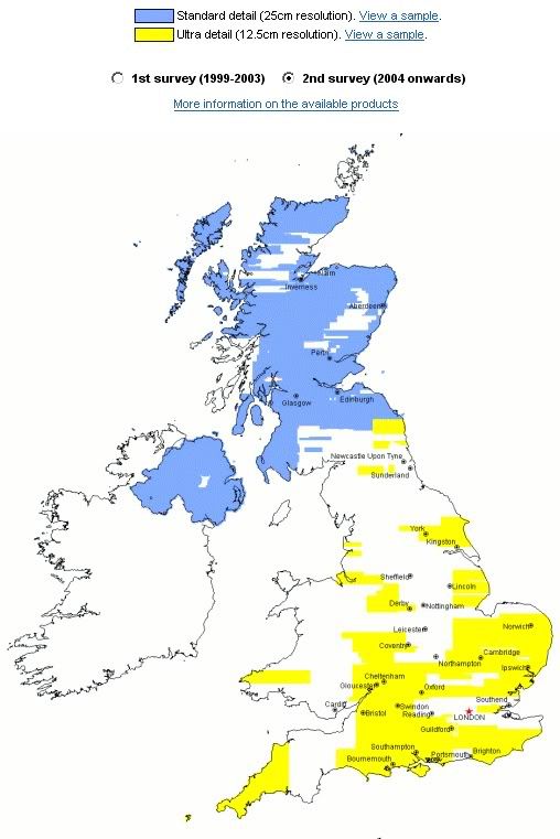
The new aerial overlay on multimap has decent photos of many areas of Scotland that weren't very well covered before on other systems.

http://www.multimap.com


I just had a look at my place and the image is at least 6 years old looking at the cars on the drive and the resolution is much lower than that of Google - nice interface though!


Great! You can't beat an aerial perspective for picking out those types of ground features. I remember being shown an aerial photo of my primary school playing field which clearly showed the old rigs - completely invisible from the ground.


It's great isn't it, I used to do loads of aerial mapping photography from a WWII Dakota - it was great fun, but I loved printing them up and seeing the stuff that was just invisible at ground level!
 

gregorach

Bushcrafter (boy, I've got a lot to say!)
Sep 15, 2005
3,723
28
50
Edinburgh
I just had a look at my place and the image is at least 6 years old looking at the cars on the drive and the resolution is much lower than that of Google - nice interface though!

The resolution on Google Maps is rubbish once you get out of the densely populated areas.
 

Grooveski

Native
Aug 9, 2005
1,707
10
53
Glasgow
I just had a look at my place and the image is at least 6 years old looking at the cars on the drive and the resolution is much lower than that of Google - nice interface though!

Multimap data is back to being pants now too.;)

Just to clarify - here's the region in question. I know there are better images for various places and good coverage of down south in other systems but a lot of the blue bit in this picture was never covered too well anywhere. It is in Getmapping(but not in multimap anymore).

Coverage.jpg
 

tyfy

Forager
Nov 4, 2006
150
0
51
Peebles, Scotland
All the mapping sites seem to be using the same photo for my area (not too surprising)

It used to be quite good about a year ago or more but it was then updated to a new one which just shows clouds.

I know it is Scotland but we do get some clear days :D
 

Apac

Tenderfoot
Feb 3, 2007
83
0
39
Hull, uk
i find google maps to be the most up to date in my area! i looked at live maps and the original posted and foud them to be at least 2-3 years old! i live in yorkshire tho so not sure if this is at all relevent!
 

BCUK Shop

We have a a number of knives, T-Shirts and other items for sale.

SHOP HERE