I've been hiking outside the UK at various points over the last 14 years. I've used maps produced by various national mapping organisations, from the Swiss, to the Dutch to the Andorrans. I've always just picked up the map and gone. Using it instinctively, my compass rarely if ever leaves my pocket (I think I've used the compass in the pub more than I have in on the hill...).
This weekend when I was in Luxembourg I picked up a couple of the local 1:20k walking maps produced by Administration du Cadastre et de la Topographie. Sitting at home now plotting a walk using the map of Boulaide-Wiltz, I wanted to give a friend online the coordinates of the trail head.
I turned the map so I could see the edges, and looked at the numbers. Then blinked.
I've been bought up on Ordnance survey mapping, using 6 figure grid references to find things is second nature, and finding them on a map is a reflex. So you can imagine how confused I was when confronted by this:
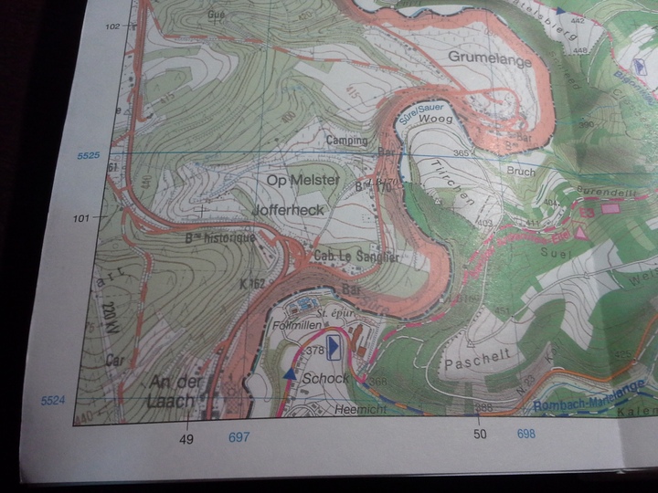
There are two sets of numbers, one in black, one in blue. The black give a rectangular grid that intersects at 90°, like I'm used to from OS. It doesn't zero pad the numbers like OS does, but you can kind of abuse them like an OS reference - 04961002 kinda gives you an 8 fig reference for a path at 368m. I think.
Then you look at the blue lines. These do not intersect at 90 degrees, they are angled slightly. I thought at first these might be lat/longs from say the WGS84, or some such. I wiggled the map round and found this:
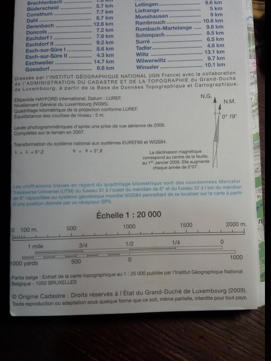
As you an see this is the 6° line, but you should also notice that the number before it is 715, and the one after is 285. The lines do not have equal spacing, these two and the 6° line are closer than the others marked in Blue lines.
I turned to the Key of the map hoping there would be something useful there to help me, and was greeted with some Greek (ok, some maths) and some French:
Excuse me for showing my ignorance in this, but how on earth do I use the coordinate system on this map to relay references to someone else using this map? What about to someone with a GPS set to WGS84?
Thanks
Julia
This weekend when I was in Luxembourg I picked up a couple of the local 1:20k walking maps produced by Administration du Cadastre et de la Topographie. Sitting at home now plotting a walk using the map of Boulaide-Wiltz, I wanted to give a friend online the coordinates of the trail head.
I turned the map so I could see the edges, and looked at the numbers. Then blinked.
I've been bought up on Ordnance survey mapping, using 6 figure grid references to find things is second nature, and finding them on a map is a reflex. So you can imagine how confused I was when confronted by this:
There are two sets of numbers, one in black, one in blue. The black give a rectangular grid that intersects at 90°, like I'm used to from OS. It doesn't zero pad the numbers like OS does, but you can kind of abuse them like an OS reference - 04961002 kinda gives you an 8 fig reference for a path at 368m. I think.
Then you look at the blue lines. These do not intersect at 90 degrees, they are angled slightly. I thought at first these might be lat/longs from say the WGS84, or some such. I wiggled the map round and found this:
As you an see this is the 6° line, but you should also notice that the number before it is 715, and the one after is 285. The lines do not have equal spacing, these two and the 6° line are closer than the others marked in Blue lines.
I turned to the Key of the map hoping there would be something useful there to help me, and was greeted with some Greek (ok, some maths) and some French:
Excuse me for showing my ignorance in this, but how on earth do I use the coordinate system on this map to relay references to someone else using this map? What about to someone with a GPS set to WGS84?
Thanks
Julia