I always like to do a solo winter camp in January and this year it happened to be convenient to do it over the New Year holiday. Personally, I can't think of a better way to see in the new year (well, actually, I can, but the twins turned me down again...), so on 31/12/11 my wife took me up to the car park at Grwyne Fawr in the Black Mountains, and promised to come back and collect me 2 days later.
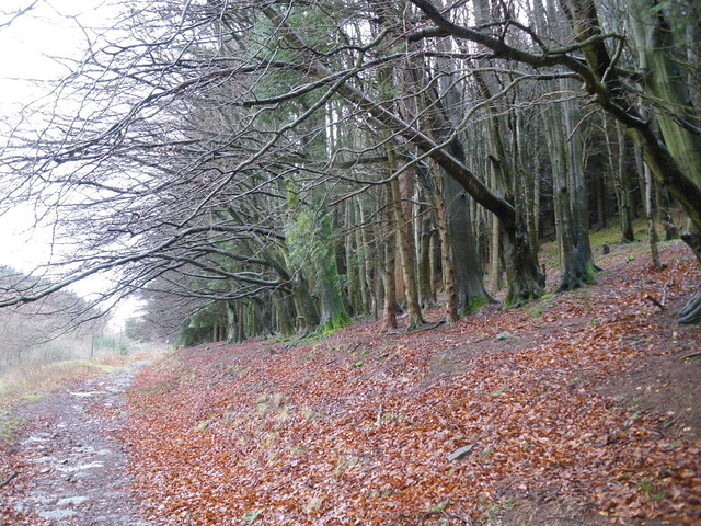
Beech woodland next to the path leaving the car park.
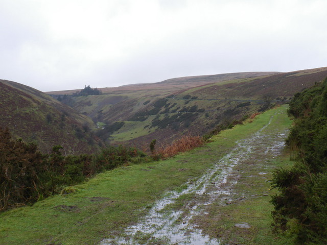
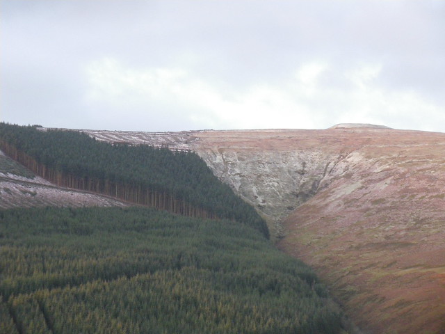
The path is actually the line of an old railway, one of the highest in Britain in its time I think, that connected a thriving industrial revolution village at the site of what is now the car park, to the dam at the top of the valley. In the pic below the dam is just visible to the left of the clump of conifers. You can see the line of the railway along the hillside.
The dam itself. Usually there is no water cascading down it, but with the rain we have had it was in full flow.

The hillside behind the dam is the base of the highest peak in the Black Mountains, Waun Fach, although it never emerged from the cloud. It isn't much of a peak anyway, just a very high cotton-grass bog.

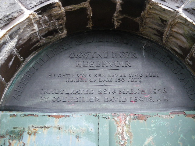
Inscription on the dam. Apparently the reservoir was intended to supply water to Abertillery, for industrial use. A long and complicated series of pipes was needed, quite a remarkable bit of engineering for the time.
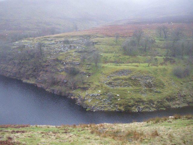
At the other end of the reservoir is the quarry that was used to obtain the stone for the reservoir. This was my destination. I ended up camped to the extreme left of this picture, at the cliff top. The shot is taken more or less directly into the North-Westerly wind that was blowing.
Grwyne Fawr Bothy, according to the fisheries bailiff that I met on the way up, the smallest in the UK. Picture taken after I had left the track, gone down the steep slope (without falling as I usually do there), and made a rather hair-raising crossing of the river that resulted in nothing worse than wet feet. The usual stepping stones were decidedly under water. The bothy was intended as a my fall-back position in case of difficulty, but it turned out to be occupied by a couple of lads armed with a lot of alcohol and a single firework (which from the sound it made at midnight was an utter flop )
)

My camping spot for the night. Not as hazardous as it looks, since there was plenty of space to the right of this pic. What you also can't see is the campfire full of rubbish left by previous campers and all of the damaged and mutilated birch and hawthorn trees that had obviously been hacked for firewood. I did a bit of a tidy up but there was more rubbish than I could handle.

The view from my chosen spot. You can see the weather closing in.

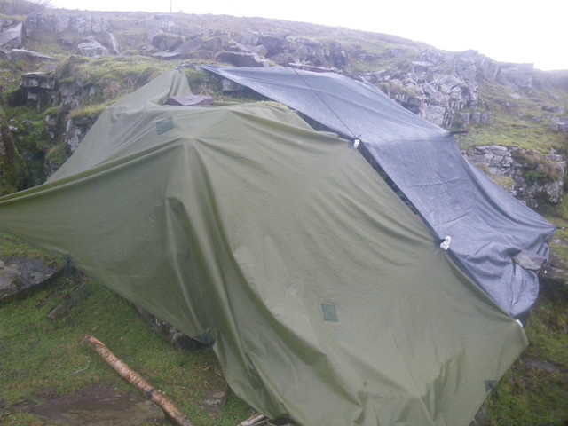
Set up. At this point the shelter was fine, but I had to use rocks to hold the tarp as pegging points were at a premium.

Set-up by the following morning. The wind shifted around more to the west in the night, and increased strength, so I had to improvise with my back-up tarp in the dark as my original shelter had become a wind tunnel. Lots of wind flap, but it worked, although the big tarp tore slightly on one of the rocks . Clingons yet again proved very handy for quickly joining two sheets together, and I recommend them to anyone.
That morning (Happy New Year!) a view of the bothy, over purple moorgrass.

I took the decision to move camp given the wind change, so went back across the river (stepping stones visible again) and back down to the dam, and then angled up across country. I'm heading for the extreme left corner of the block of conifers, where there would be good shelter. The railway track is to the right, where the two walkers are. In the background is Chwarel y fan, the highest point in the old county of Gwent.

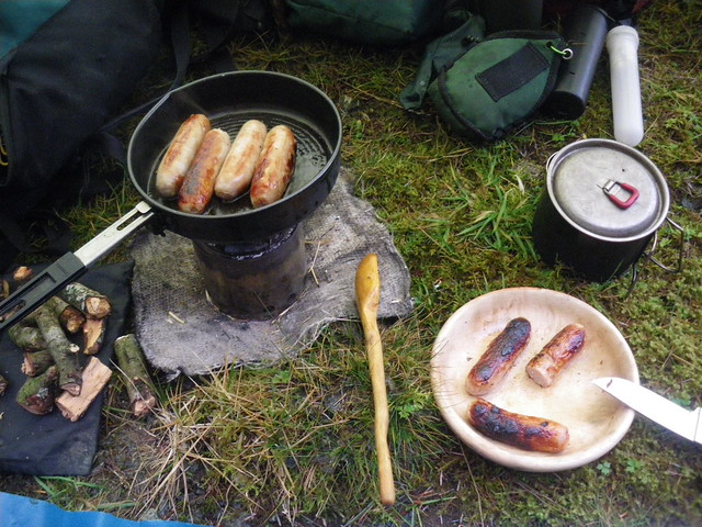
Reaching my destination it was so still there was mist lying! I set up a small tarp and cooked up some lunch. First use of my turned hornbeam plate. Note the seasoned apple wood that I took along specially because of the weather.
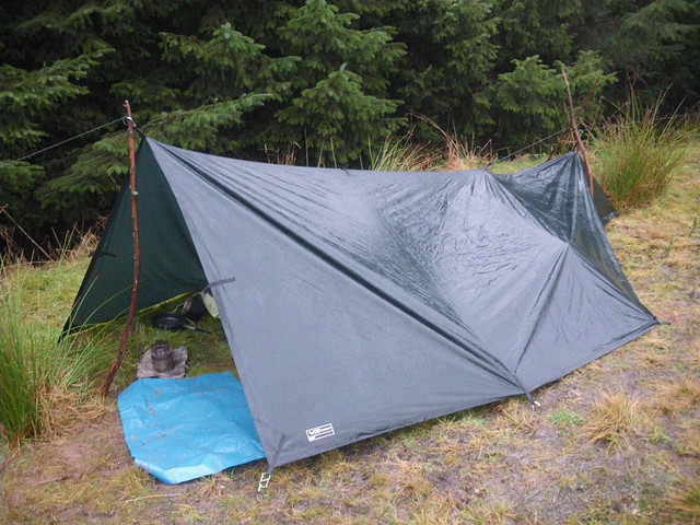
After lunch, I decided to set up camp, whereupon it hammered down, which is my excuse for this appalling bit of tarpology. Cunningly pitched on sodden mossy ground, on a slope, for maximum discomfort.
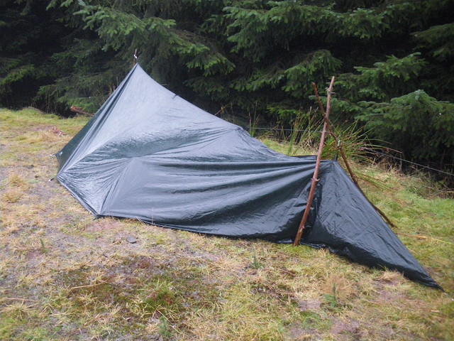
The other end. Yes, this end fell down in the night as the wind shifted back again, but the DD XL tarp is so big it didn't matter, because I was at the other end. Not the most comfortable night ever, as I'd managed to get my down sleeping bag wet, so it didn't insulate well, but I was ok. Getting dressed the next morning into cold wet clothes was horrible though.
Never mind, this was the view back up the valley a few minutes after sunrise. Absolutely glorious - I was laughing just for the joy of it. The view only lasted a few minutes more as the sun rose and the shadow contrast disappeared.

The other reason was cold that morning. A clear night had led to frost, and I was camped just above the frost line. This is the view directly across the valley to the second-highest (and easily the best) peak in the Black Mountains, Pen y Gadair Fawr (meaning peak of the chair, or something like that). Just about the windiest place I know of, but the views are incredible, and it is one of my favourite summer camping spots.
And finally, down through the forestry to wait by the river for my wife to pick me up, which she duly did. Lots of people arriving to go up the path to the dam, from pensioners with sticks (and a pair of pensioners who walked faster than I do and looked super-fit) to families with little children just able to walk. It is a popular spot because of the good parking and easy gradient paths. Worth a visit if you have never been there.

All in all, a really enjoyable trip, despite a few 'interesting' moments. Thanks for looking.
Beech woodland next to the path leaving the car park.
The path is actually the line of an old railway, one of the highest in Britain in its time I think, that connected a thriving industrial revolution village at the site of what is now the car park, to the dam at the top of the valley. In the pic below the dam is just visible to the left of the clump of conifers. You can see the line of the railway along the hillside.
The dam itself. Usually there is no water cascading down it, but with the rain we have had it was in full flow.
The hillside behind the dam is the base of the highest peak in the Black Mountains, Waun Fach, although it never emerged from the cloud. It isn't much of a peak anyway, just a very high cotton-grass bog.
Inscription on the dam. Apparently the reservoir was intended to supply water to Abertillery, for industrial use. A long and complicated series of pipes was needed, quite a remarkable bit of engineering for the time.
At the other end of the reservoir is the quarry that was used to obtain the stone for the reservoir. This was my destination. I ended up camped to the extreme left of this picture, at the cliff top. The shot is taken more or less directly into the North-Westerly wind that was blowing.
Grwyne Fawr Bothy, according to the fisheries bailiff that I met on the way up, the smallest in the UK. Picture taken after I had left the track, gone down the steep slope (without falling as I usually do there), and made a rather hair-raising crossing of the river that resulted in nothing worse than wet feet. The usual stepping stones were decidedly under water. The bothy was intended as a my fall-back position in case of difficulty, but it turned out to be occupied by a couple of lads armed with a lot of alcohol and a single firework (which from the sound it made at midnight was an utter flop
)
My camping spot for the night. Not as hazardous as it looks, since there was plenty of space to the right of this pic. What you also can't see is the campfire full of rubbish left by previous campers and all of the damaged and mutilated birch and hawthorn trees that had obviously been hacked for firewood. I did a bit of a tidy up but there was more rubbish than I could handle.
The view from my chosen spot. You can see the weather closing in.
Set up. At this point the shelter was fine, but I had to use rocks to hold the tarp as pegging points were at a premium.
Set-up by the following morning. The wind shifted around more to the west in the night, and increased strength, so I had to improvise with my back-up tarp in the dark as my original shelter had become a wind tunnel. Lots of wind flap, but it worked, although the big tarp tore slightly on one of the rocks
. Clingons yet again proved very handy for quickly joining two sheets together, and I recommend them to anyone.
That morning (Happy New Year!) a view of the bothy, over purple moorgrass.
I took the decision to move camp given the wind change, so went back across the river (stepping stones visible again) and back down to the dam, and then angled up across country. I'm heading for the extreme left corner of the block of conifers, where there would be good shelter. The railway track is to the right, where the two walkers are. In the background is Chwarel y fan, the highest point in the old county of Gwent.
Reaching my destination it was so still there was mist lying! I set up a small tarp and cooked up some lunch. First use of my turned hornbeam plate. Note the seasoned apple wood that I took along specially because of the weather.
After lunch, I decided to set up camp, whereupon it hammered down, which is my excuse for this appalling bit of tarpology. Cunningly pitched on sodden mossy ground, on a slope, for maximum discomfort.
The other end. Yes, this end fell down in the night as the wind shifted back again, but the DD XL tarp is so big it didn't matter, because I was at the other end. Not the most comfortable night ever, as I'd managed to get my down sleeping bag wet, so it didn't insulate well, but I was ok. Getting dressed the next morning into cold wet clothes was horrible though.
Never mind, this was the view back up the valley a few minutes after sunrise. Absolutely glorious - I was laughing just for the joy of it. The view only lasted a few minutes more as the sun rose and the shadow contrast disappeared.
The other reason was cold that morning. A clear night had led to frost, and I was camped just above the frost line. This is the view directly across the valley to the second-highest (and easily the best) peak in the Black Mountains, Pen y Gadair Fawr (meaning peak of the chair, or something like that). Just about the windiest place I know of, but the views are incredible, and it is one of my favourite summer camping spots.
And finally, down through the forestry to wait by the river for my wife to pick me up, which she duly did. Lots of people arriving to go up the path to the dam, from pensioners with sticks (and a pair of pensioners who walked faster than I do and looked super-fit) to families with little children just able to walk. It is a popular spot because of the good parking and easy gradient paths. Worth a visit if you have never been there.
All in all, a really enjoyable trip, despite a few 'interesting' moments. Thanks for looking.